You are here: Home > Network List > MN - MEDNET Project Stations List
> Station AQU L'Aquila, Italy > Earthquake Result Viewer
AQU L'Aquila, Italy - Earthquake Result Viewer
| Earthquake location: |
Kuril Islands |
| Earthquake latitude/longitude: |
45.6/151.7 |
| Earthquake time(UTC): |
1991/12/13 (347) 18:59:11 GMT |
| Earthquake Depth: |
52 km |
| Earthquake Magnitude: |
6.2 MB |
| Earthquake Catalog/Contributor: |
WHDF/NEIC |
|
| Network: |
MN MEDNET Project |
| Station: |
AQU L'Aquila, Italy |
| Lat/Lon: |
42.35 N/13.40 E |
| Elevation: |
710 m |
|
| Distance: |
84.9 deg |
| Az: |
330.335 deg |
| Baz: |
27.978 deg |
| Ray Param: |
0.045051135 |
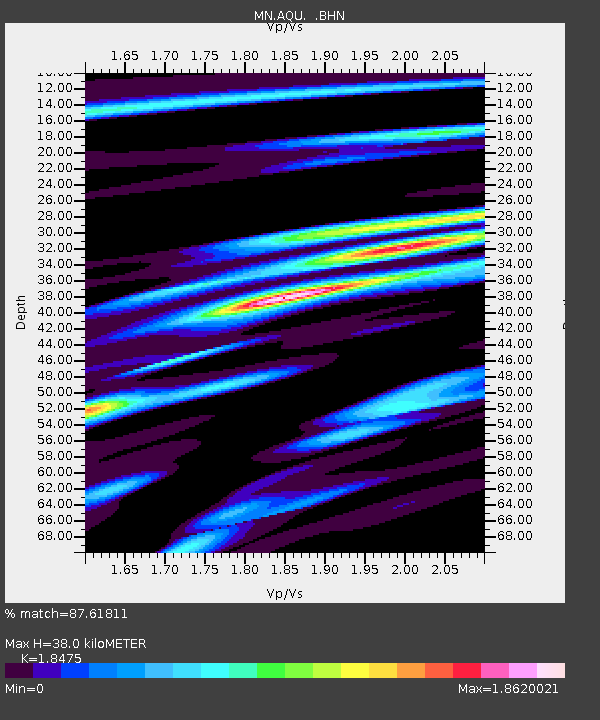
| Estimated Moho Depth: |
38.0 km |
| Estimated Crust Vp/Vs: |
1.85 |
| Assumed Crust Vp: |
6.276 km/s |
| Estimated Crust Vs: |
3.397 km/s |
| Estimated Crust Poisson's Ratio: |
0.29 |
|
| Radial Match: |
87.61811 % |
| Radial Bump: |
400 |
| Transverse Match: |
84.34803 % |
| Transverse Bump: |
400 |
| SOD ConfigId: |
16938 |
| Insert Time: |
2010-03-08 16:33:06.728 +0000 |
| GWidth: |
2.5 |
| Max Bumps: |
400 |
| Tol: |
0.001 |
|
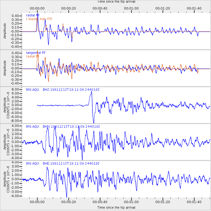
Signal To Noise
| Channel | StoN | STA | LTA |
| MN:AQU: :BHN:19911213T19:11:09.244019Z | 4.8870125 | 9.2527154E-7 | 1.8933275E-7 |
| MN:AQU: :BHE:19911213T19:11:09.244019Z | 3.1365645 | 5.5536475E-7 | 1.770615E-7 |
| MN:AQU: :BHZ:19911213T19:11:09.244019Z | 28.70869 | 3.023815E-6 | 1.05327516E-7 |
| Arrivals |
| Ps | 5.2 SECOND |
| PpPs | 17 SECOND |
| PsPs/PpSs | 22 SECOND |


