You are here: Home > Network List > MN - MEDNET Project Stations List
> Station AQU L'Aquila, Italy > Earthquake Result Viewer
AQU L'Aquila, Italy - Earthquake Result Viewer
| Earthquake location: |
Kuril Islands |
| Earthquake latitude/longitude: |
45.5/151.0 |
| Earthquake time(UTC): |
1991/12/22 (356) 08:43:13 GMT |
| Earthquake Depth: |
26 km |
| Earthquake Magnitude: |
6.3 MB, 7.4 MS |
| Earthquake Catalog/Contributor: |
WHDF/NEIC |
|
| Network: |
MN MEDNET Project |
| Station: |
AQU L'Aquila, Italy |
| Lat/Lon: |
42.35 N/13.40 E |
| Elevation: |
710 m |
|
| Distance: |
84.7 deg |
| Az: |
329.899 deg |
| Baz: |
28.428 deg |
| Ray Param: |
0.04523186 |
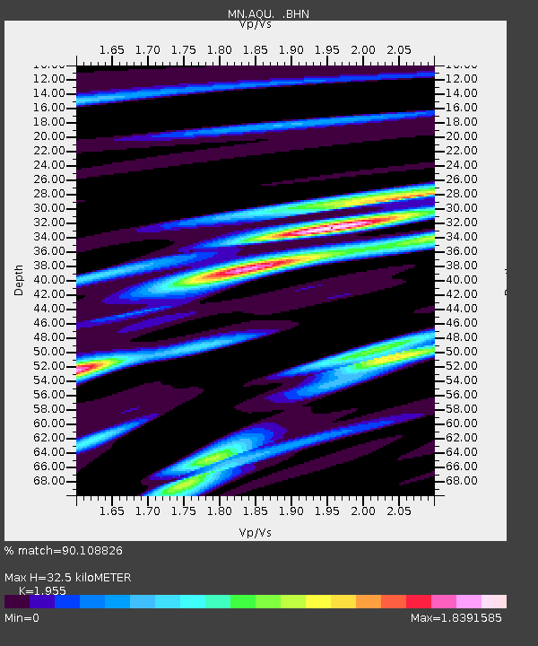
| Estimated Moho Depth: |
32.5 km |
| Estimated Crust Vp/Vs: |
1.96 |
| Assumed Crust Vp: |
6.276 km/s |
| Estimated Crust Vs: |
3.21 km/s |
| Estimated Crust Poisson's Ratio: |
0.32 |
|
| Radial Match: |
90.108826 % |
| Radial Bump: |
400 |
| Transverse Match: |
83.19254 % |
| Transverse Bump: |
400 |
| SOD ConfigId: |
16938 |
| Insert Time: |
2010-03-08 16:33:11.177 +0000 |
| GWidth: |
2.5 |
| Max Bumps: |
400 |
| Tol: |
0.001 |
|
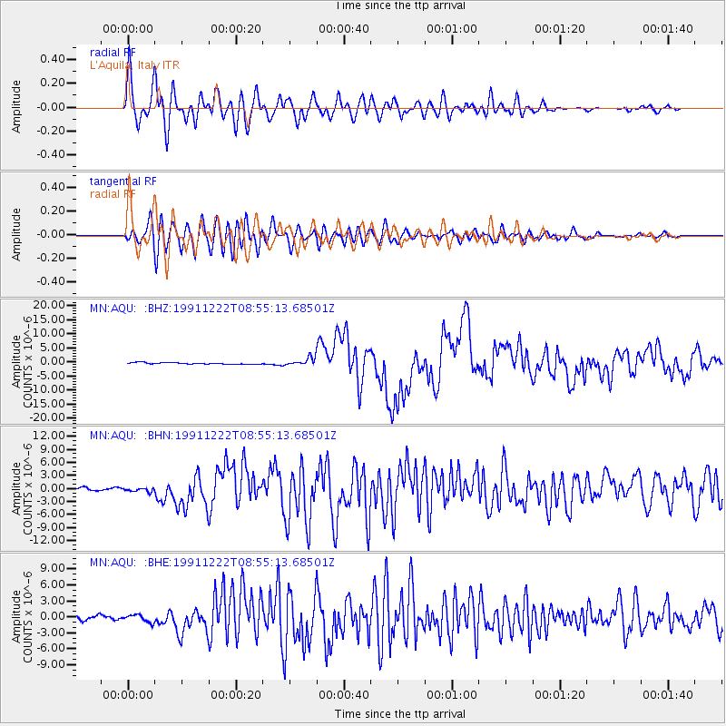
Signal To Noise
| Channel | StoN | STA | LTA |
| MN:AQU: :BHN:19911222T08:55:13.68501Z | 1.0906655 | 3.940921E-7 | 3.613318E-7 |
| MN:AQU: :BHE:19911222T08:55:13.68501Z | 1.1624893 | 7.1888644E-7 | 6.184027E-7 |
| MN:AQU: :BHZ:19911222T08:55:13.68501Z | 5.1653757 | 1.4282018E-6 | 2.7649523E-7 |
| Arrivals |
| Ps | 5.1 SECOND |
| PpPs | 15 SECOND |
| PsPs/PpSs | 20 SECOND |


