You are here: Home > Network List > US - United States National Seismic Network Stations List
> Station PKME Peaks-Kenny State Park, Maine, USA > Earthquake Result Viewer
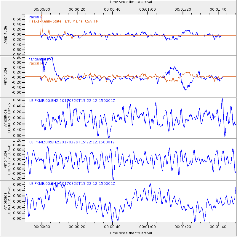
PKME Peaks-Kenny State Park, Maine, USA - Earthquake Result Viewer
*The percent match for this event was below the threshold and hence no stack was calculated.
| Earthquake location: |
Gulf Of California |
| Earthquake latitude/longitude: |
26.0/-110.0 |
| Earthquake time(UTC): |
2017/03/29 (088) 15:15:26 GMT |
| Earthquake Depth: |
10 km |
| Earthquake Magnitude: |
5.7 Mww |
| Earthquake Catalog/Contributor: |
NEIC PDE/us |
|
| Network: |
US United States National Seismic Network |
| Station: |
PKME Peaks-Kenny State Park, Maine, USA |
| Lat/Lon: |
45.26 N/69.29 W |
| Elevation: |
108 m |
|
| Distance: |
37.8 deg |
| Az: |
48.766 deg |
| Baz: |
253.406 deg |
| Ray Param: |
$rayparam |
*The percent match for this event was below the threshold and hence was not used in the summary stack. |
|
| Radial Match: |
25.169952 % |
| Radial Bump: |
400 |
| Transverse Match: |
24.111488 % |
| Transverse Bump: |
400 |
| SOD ConfigId: |
2028011 |
| Insert Time: |
2017-04-12 15:19:35.981 +0000 |
| GWidth: |
2.5 |
| Max Bumps: |
400 |
| Tol: |
0.001 |
|
Signal To Noise
| Channel | StoN | STA | LTA |
| US:PKME:00:BHZ:20170329T15:22:12.150001Z | 0.9716459 | 4.0217012E-7 | 4.1390604E-7 |
| US:PKME:00:BH1:20170329T15:22:12.150001Z | 1.2915156 | 8.8219093E-7 | 6.830664E-7 |
| US:PKME:00:BH2:20170329T15:22:12.150001Z | 1.2705626 | 2.970459E-7 | 2.3379081E-7 |
| Arrivals |
| Ps | |
| PpPs | |
| PsPs/PpSs | |


