You are here: Home > Network List > MN - MEDNET Project Stations List
> Station AQU L'Aquila, Italy > Earthquake Result Viewer
AQU L'Aquila, Italy - Earthquake Result Viewer
| Earthquake location: |
Northern Mid-Atlantic Ridge |
| Earthquake latitude/longitude: |
23.8/-45.4 |
| Earthquake time(UTC): |
1991/06/10 (161) 17:35:49 GMT |
| Earthquake Depth: |
10 km |
| Earthquake Magnitude: |
6.2 MB, 6.4 MS |
| Earthquake Catalog/Contributor: |
WHDF/NEIC |
|
| Network: |
MN MEDNET Project |
| Station: |
AQU L'Aquila, Italy |
| Lat/Lon: |
42.35 N/13.40 E |
| Elevation: |
710 m |
|
| Distance: |
51.6 deg |
| Az: |
53.962 deg |
| Baz: |
268.383 deg |
| Ray Param: |
0.067304656 |
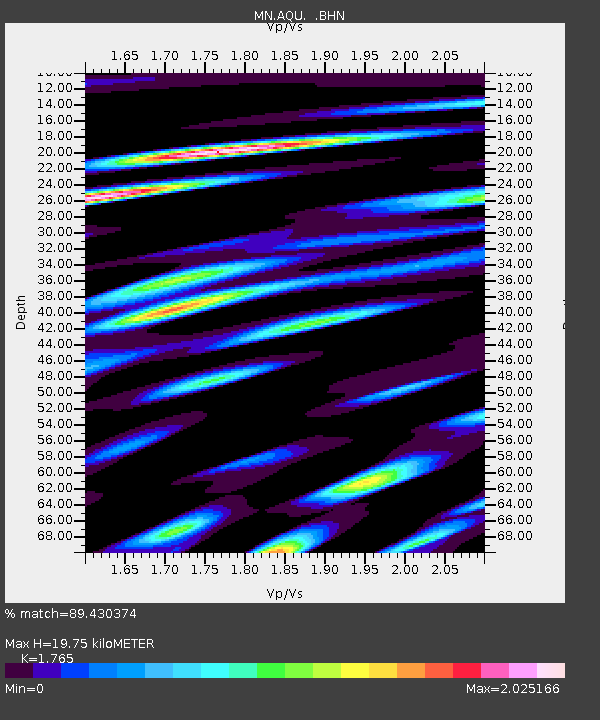
| Estimated Moho Depth: |
19.75 km |
| Estimated Crust Vp/Vs: |
1.76 |
| Assumed Crust Vp: |
6.276 km/s |
| Estimated Crust Vs: |
3.556 km/s |
| Estimated Crust Poisson's Ratio: |
0.26 |
|
| Radial Match: |
89.430374 % |
| Radial Bump: |
400 |
| Transverse Match: |
89.05331 % |
| Transverse Bump: |
400 |
| SOD ConfigId: |
16938 |
| Insert Time: |
2010-03-08 16:33:18.764 +0000 |
| GWidth: |
2.5 |
| Max Bumps: |
400 |
| Tol: |
0.001 |
|
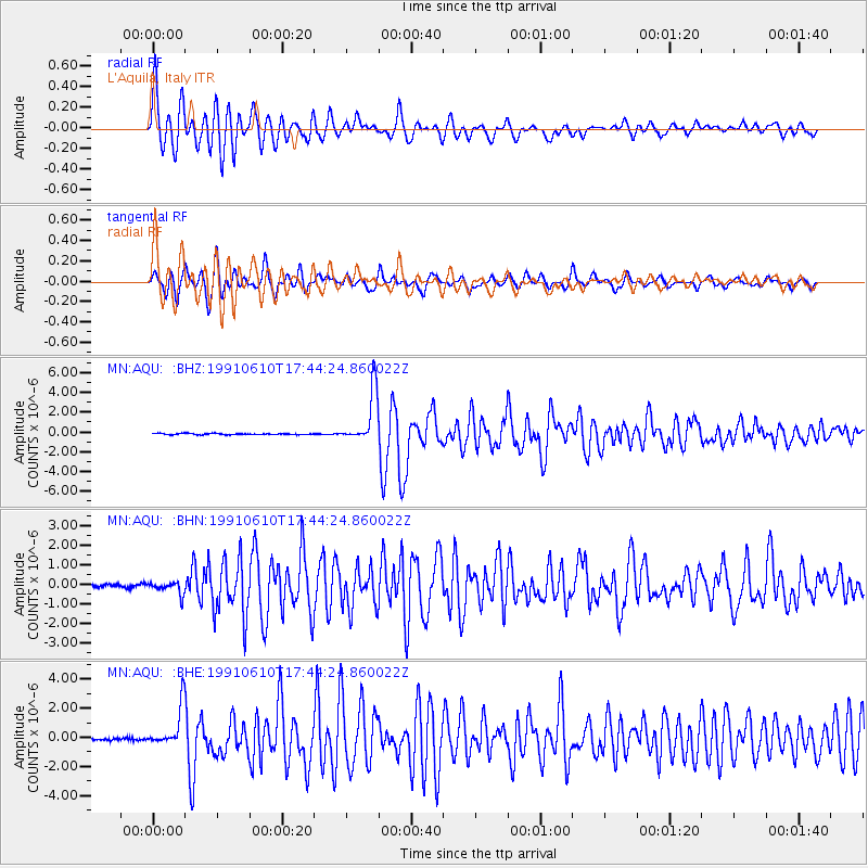
Signal To Noise
| Channel | StoN | STA | LTA |
| MN:AQU: :BHN:19910610T17:44:24.860022Z | 4.4921746 | 3.2572996E-7 | 7.2510524E-8 |
| MN:AQU: :BHE:19910610T17:44:24.860022Z | 20.477438 | 1.3560333E-6 | 6.622085E-8 |
| MN:AQU: :BHZ:19910610T17:44:24.860022Z | 42.822277 | 2.6553312E-6 | 6.2008176E-8 |
| Arrivals |
| Ps | 2.5 SECOND |
| PpPs | 8.2 SECOND |
| PsPs/PpSs | 11 SECOND |


