You are here: Home > Network List > MN - MEDNET Project Stations List
> Station AQU L'Aquila, Italy > Earthquake Result Viewer
AQU L'Aquila, Italy - Earthquake Result Viewer
| Earthquake location: |
Southern Sumatra, Indonesia |
| Earthquake latitude/longitude: |
-1.1/99.9 |
| Earthquake time(UTC): |
1991/07/02 (183) 05:14:30 GMT |
| Earthquake Depth: |
54 km |
| Earthquake Magnitude: |
5.9 MB, 6.2 UNKNOWN |
| Earthquake Catalog/Contributor: |
WHDF/NEIC |
|
| Network: |
MN MEDNET Project |
| Station: |
AQU L'Aquila, Italy |
| Lat/Lon: |
42.35 N/13.40 E |
| Elevation: |
710 m |
|
| Distance: |
88.2 deg |
| Az: |
312.247 deg |
| Baz: |
93.17 deg |
| Ray Param: |
0.042695504 |
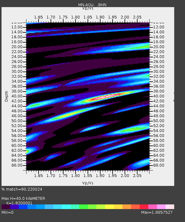
| Estimated Moho Depth: |
40.0 km |
| Estimated Crust Vp/Vs: |
1.92 |
| Assumed Crust Vp: |
6.276 km/s |
| Estimated Crust Vs: |
3.269 km/s |
| Estimated Crust Poisson's Ratio: |
0.31 |
|
| Radial Match: |
90.220024 % |
| Radial Bump: |
400 |
| Transverse Match: |
90.52687 % |
| Transverse Bump: |
400 |
| SOD ConfigId: |
16938 |
| Insert Time: |
2010-03-08 16:33:20.240 +0000 |
| GWidth: |
2.5 |
| Max Bumps: |
400 |
| Tol: |
0.001 |
|
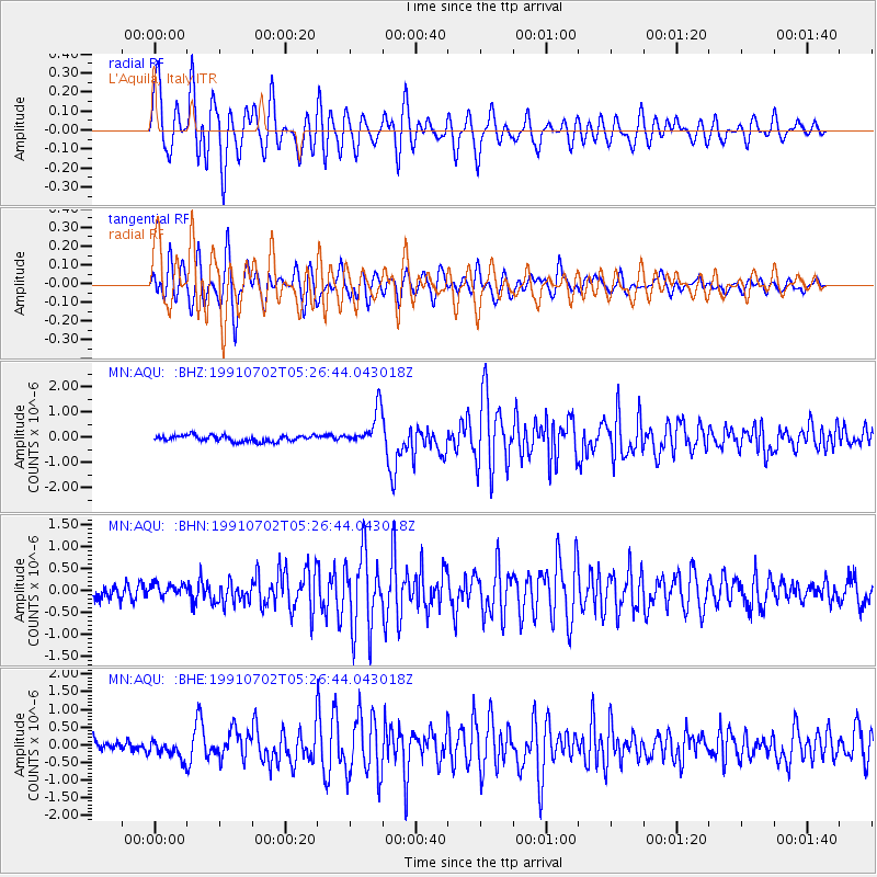
Signal To Noise
| Channel | StoN | STA | LTA |
| MN:AQU: :BHN:19910702T05:26:44.043018Z | 1.0336585 | 1.5124591E-7 | 1.4632097E-7 |
| MN:AQU: :BHE:19910702T05:26:44.043018Z | 1.6124666 | 2.7034022E-7 | 1.6765632E-7 |
| MN:AQU: :BHZ:19910702T05:26:44.043018Z | 6.0027165 | 7.164771E-7 | 1.1935882E-7 |
| Arrivals |
| Ps | 6.0 SECOND |
| PpPs | 18 SECOND |
| PsPs/PpSs | 24 SECOND |


