You are here: Home > Network List > MN - MEDNET Project Stations List
> Station AQU L'Aquila, Italy > Earthquake Result Viewer
AQU L'Aquila, Italy - Earthquake Result Viewer
| Earthquake location: |
East Of Severnaya Zemlya |
| Earthquake latitude/longitude: |
79.2/124.5 |
| Earthquake time(UTC): |
1992/02/17 (048) 00:01:56 GMT |
| Earthquake Depth: |
10 km |
| Earthquake Magnitude: |
6.0 MB, 5.5 MS |
| Earthquake Catalog/Contributor: |
WHDF/NEIC |
|
| Network: |
MN MEDNET Project |
| Station: |
AQU L'Aquila, Italy |
| Lat/Lon: |
42.35 N/13.40 E |
| Elevation: |
710 m |
|
| Distance: |
52.5 deg |
| Az: |
299.388 deg |
| Baz: |
12.843 deg |
| Ray Param: |
0.06671161 |
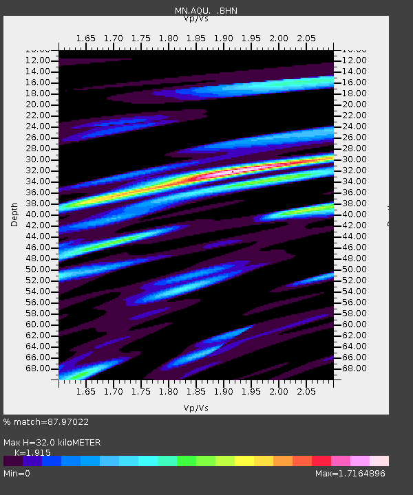
| Estimated Moho Depth: |
32.0 km |
| Estimated Crust Vp/Vs: |
1.91 |
| Assumed Crust Vp: |
6.276 km/s |
| Estimated Crust Vs: |
3.277 km/s |
| Estimated Crust Poisson's Ratio: |
0.31 |
|
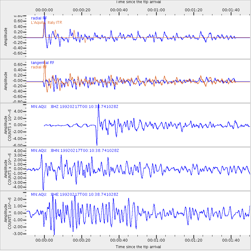
| Radial Match: |
87.97022 % |
| Radial Bump: |
398 |
| Transverse Match: |
81.6685 % |
| Transverse Bump: |
400 |
| SOD ConfigId: |
16938 |
| Insert Time: |
2010-03-08 16:33:24.105 +0000 |
| GWidth: |
2.5 |
| Max Bumps: |
400 |
| Tol: |
0.001 |
|
Signal To Noise
| Channel | StoN | STA | LTA |
| MN:AQU: :BHN:19920217T00:10:38.741028Z | 8.479208 | 1.6553751E-6 | 1.9522754E-7 |
| MN:AQU: :BHE:19920217T00:10:38.741028Z | 5.0895534 | 1.2227914E-6 | 2.4025516E-7 |
| MN:AQU: :BHZ:19920217T00:10:38.741028Z | 8.74782 | 1.9887307E-6 | 2.2734017E-7 |
| Arrivals |
| Ps | 4.9 SECOND |
| PpPs | 14 SECOND |
| PsPs/PpSs | 19 SECOND |


