You are here: Home > Network List > MN - MEDNET Project Stations List
> Station AQU L'Aquila, Italy > Earthquake Result Viewer
AQU L'Aquila, Italy - Earthquake Result Viewer
| Earthquake location: |
East Of Kuril Islands |
| Earthquake latitude/longitude: |
47.6/155.6 |
| Earthquake time(UTC): |
1992/05/28 (149) 21:24:50 GMT |
| Earthquake Depth: |
49 km |
| Earthquake Magnitude: |
6.0 MB, 5.3 MS |
| Earthquake Catalog/Contributor: |
WHDF/NEIC |
|
| Network: |
MN MEDNET Project |
| Station: |
AQU L'Aquila, Italy |
| Lat/Lon: |
42.35 N/13.40 E |
| Elevation: |
710 m |
|
| Distance: |
84.4 deg |
| Az: |
332.858 deg |
| Baz: |
24.619 deg |
| Ray Param: |
0.04542234 |
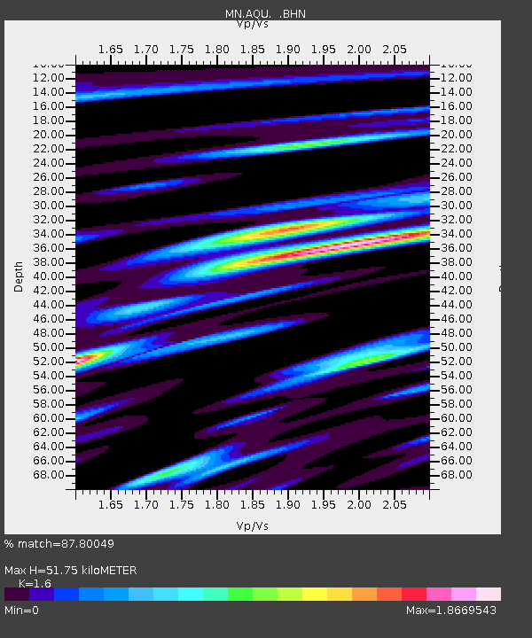
| Estimated Moho Depth: |
51.75 km |
| Estimated Crust Vp/Vs: |
1.60 |
| Assumed Crust Vp: |
6.276 km/s |
| Estimated Crust Vs: |
3.922 km/s |
| Estimated Crust Poisson's Ratio: |
0.18 |
|
| Radial Match: |
87.80049 % |
| Radial Bump: |
400 |
| Transverse Match: |
88.8916 % |
| Transverse Bump: |
400 |
| SOD ConfigId: |
16938 |
| Insert Time: |
2010-03-08 16:33:33.950 +0000 |
| GWidth: |
2.5 |
| Max Bumps: |
400 |
| Tol: |
0.001 |
|

Signal To Noise
| Channel | StoN | STA | LTA |
| MN:AQU: :BHN:19920528T21:36:46.844006Z | 1.7783681 | 1.216425E-7 | 6.840119E-8 |
| MN:AQU: :BHE:19920528T21:36:46.844006Z | 1.2459278 | 9.6846755E-8 | 7.7730625E-8 |
| MN:AQU: :BHZ:19920528T21:36:46.844006Z | 7.0547647 | 3.9306437E-7 | 5.5716153E-8 |
| Arrivals |
| Ps | 5.1 SECOND |
| PpPs | 21 SECOND |
| PsPs/PpSs | 26 SECOND |


