You are here: Home > Network List > MN - MEDNET Project Stations List
> Station AQU L'Aquila, Italy > Earthquake Result Viewer
AQU L'Aquila, Italy - Earthquake Result Viewer
| Earthquake location: |
Myanmar |
| Earthquake latitude/longitude: |
24.0/95.9 |
| Earthquake time(UTC): |
1992/06/15 (167) 02:48:56 GMT |
| Earthquake Depth: |
16 km |
| Earthquake Magnitude: |
5.7 MB, 6.3 MS |
| Earthquake Catalog/Contributor: |
WHDF/NEIC |
|
| Network: |
MN MEDNET Project |
| Station: |
AQU L'Aquila, Italy |
| Lat/Lon: |
42.35 N/13.40 E |
| Elevation: |
710 m |
|
| Distance: |
68.9 deg |
| Az: |
308.029 deg |
| Baz: |
76.397 deg |
| Ray Param: |
0.055989213 |
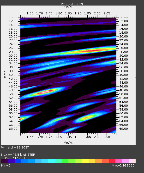
| Estimated Moho Depth: |
48.5 km |
| Estimated Crust Vp/Vs: |
1.73 |
| Assumed Crust Vp: |
6.276 km/s |
| Estimated Crust Vs: |
3.622 km/s |
| Estimated Crust Poisson's Ratio: |
0.25 |
|
| Radial Match: |
89.8037 % |
| Radial Bump: |
400 |
| Transverse Match: |
86.54684 % |
| Transverse Bump: |
400 |
| SOD ConfigId: |
16938 |
| Insert Time: |
2010-03-08 16:33:35.243 +0000 |
| GWidth: |
2.5 |
| Max Bumps: |
400 |
| Tol: |
0.001 |
|
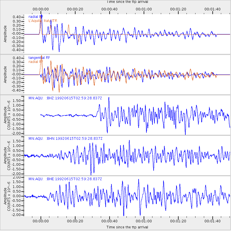
Signal To Noise
| Channel | StoN | STA | LTA |
| MN:AQU: :BHN:19920615T02:59:28.837Z | 1.1530766 | 8.032141E-8 | 6.965834E-8 |
| MN:AQU: :BHE:19920615T02:59:28.837Z | 2.79125 | 1.6285456E-7 | 5.8344668E-8 |
| MN:AQU: :BHZ:19920615T02:59:28.837Z | 7.901229 | 4.280849E-7 | 5.417953E-8 |
| Arrivals |
| Ps | 5.9 SECOND |
| PpPs | 20 SECOND |
| PsPs/PpSs | 26 SECOND |


