You are here: Home > Network List > MN - MEDNET Project Stations List
> Station AQU L'Aquila, Italy > Earthquake Result Viewer
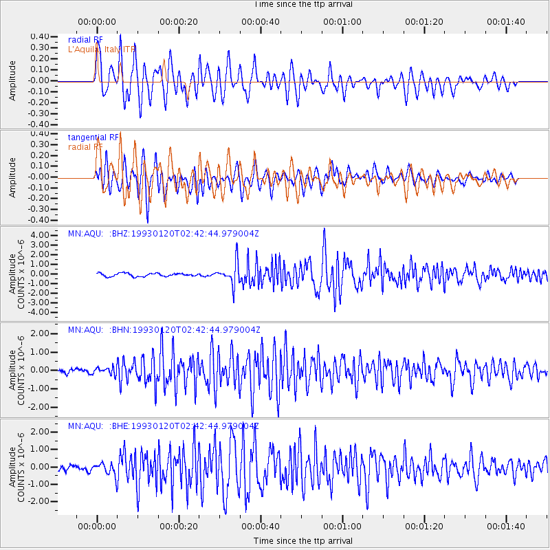
AQU L'Aquila, Italy - Earthquake Result Viewer

| Earthquake location: |
Northern Sumatra, Indonesia |
| Earthquake latitude/longitude: |
3.1/97.7 |
| Earthquake time(UTC): |
1993/01/20 (020) 02:30:55 GMT |
| Earthquake Depth: |
71 km |
| Earthquake Magnitude: |
6.2 MB |
| Earthquake Catalog/Contributor: |
WHDF/NEIC |
|
| Network: |
MN MEDNET Project |
| Station: |
AQU L'Aquila, Italy |
| Lat/Lon: |
42.35 N/13.40 E |
| Elevation: |
710 m |
|
| Distance: |
83.7 deg |
| Az: |
312.098 deg |
| Baz: |
91.6 deg |
| Ray Param: |
0.04586079 |
| Estimated Moho Depth: |
41.0 km |
| Estimated Crust Vp/Vs: |
1.88 |
| Assumed Crust Vp: |
6.276 km/s |
| Estimated Crust Vs: |
3.329 km/s |
| Estimated Crust Poisson's Ratio: |
0.30 |
|
| Radial Match: |
88.91729 % |
| Radial Bump: |
400 |
| Transverse Match: |
85.776596 % |
| Transverse Bump: |
400 |
| SOD ConfigId: |
16938 |
| Insert Time: |
2010-03-08 16:33:54.865 +0000 |
| GWidth: |
2.5 |
| Max Bumps: |
400 |
| Tol: |
0.001 |
|
Signal To Noise
| Channel | StoN | STA | LTA |
| MN:AQU: :BHN:19930120T02:42:44.979004Z | 0.7681296 | 2.0555059E-7 | 2.6759886E-7 |
| MN:AQU: :BHE:19930120T02:42:44.979004Z | 2.2958243 | 3.8369734E-7 | 1.6712836E-7 |
| MN:AQU: :BHZ:19930120T02:42:44.979004Z | 7.1668653 | 1.1642373E-6 | 1.6244721E-7 |
| Arrivals |
| Ps | 5.9 SECOND |
| PpPs | 18 SECOND |
| PsPs/PpSs | 24 SECOND |


