You are here: Home > Network List > MN - MEDNET Project Stations List
> Station AQU L'Aquila, Italy > Earthquake Result Viewer
AQU L'Aquila, Italy - Earthquake Result Viewer
| Earthquake location: |
Afghanistan-Tajikistan Bord Reg. |
| Earthquake latitude/longitude: |
36.4/71.6 |
| Earthquake time(UTC): |
1993/09/18 (261) 05:02:27 GMT |
| Earthquake Depth: |
117 km |
| Earthquake Magnitude: |
6.1 MB, 6.4 UNKNOWN, 6.1 MW |
| Earthquake Catalog/Contributor: |
WHDF/NEIC |
|
| Network: |
MN MEDNET Project |
| Station: |
AQU L'Aquila, Italy |
| Lat/Lon: |
42.35 N/13.40 E |
| Elevation: |
710 m |
|
| Distance: |
44.6 deg |
| Az: |
296.284 deg |
| Baz: |
77.497 deg |
| Ray Param: |
0.0713823 |
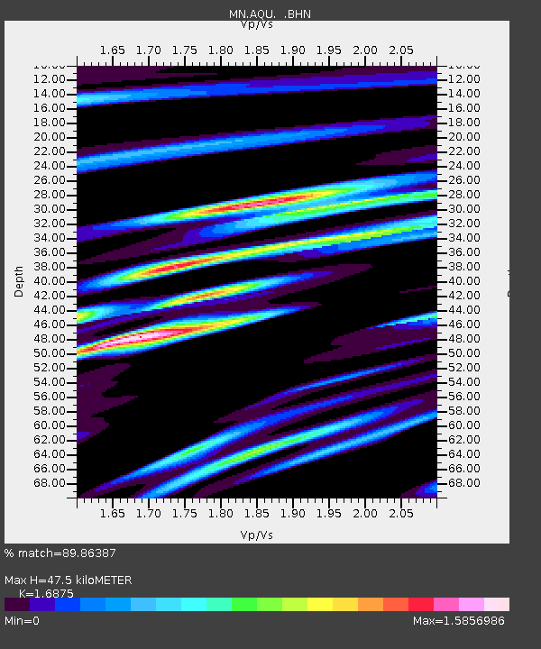
| Estimated Moho Depth: |
47.5 km |
| Estimated Crust Vp/Vs: |
1.69 |
| Assumed Crust Vp: |
6.276 km/s |
| Estimated Crust Vs: |
3.719 km/s |
| Estimated Crust Poisson's Ratio: |
0.23 |
|
| Radial Match: |
89.86387 % |
| Radial Bump: |
400 |
| Transverse Match: |
83.297905 % |
| Transverse Bump: |
400 |
| SOD ConfigId: |
16938 |
| Insert Time: |
2010-03-08 16:34:10.624 +0000 |
| GWidth: |
2.5 |
| Max Bumps: |
400 |
| Tol: |
0.001 |
|

Signal To Noise
| Channel | StoN | STA | LTA |
| MN:AQU: :BHN:19930918T05:09:57.559009Z | 2.9508028 | 2.2785889E-7 | 7.721929E-8 |
| MN:AQU: :BHE:19930918T05:09:57.559009Z | 11.522016 | 7.6636707E-7 | 6.651328E-8 |
| MN:AQU: :BHZ:19930918T05:09:57.559009Z | 19.414433 | 1.2830213E-6 | 6.608596E-8 |
| Arrivals |
| Ps | 5.5 SECOND |
| PpPs | 19 SECOND |
| PsPs/PpSs | 25 SECOND |


