You are here: Home > Network List > TA - USArray Transportable Network (new EarthScope stations) Stations List
> Station A21K Barrow, AK, USA > Earthquake Result Viewer
A21K Barrow, AK, USA - Earthquake Result Viewer
| Earthquake location: |
Vanuatu Islands |
| Earthquake latitude/longitude: |
-14.4/167.7 |
| Earthquake time(UTC): |
2019/12/14 (348) 04:57:37 GMT |
| Earthquake Depth: |
27 km |
| Earthquake Magnitude: |
5.9 Mww |
| Earthquake Catalog/Contributor: |
NEIC PDE/us |
|
| Network: |
TA USArray Transportable Network (new EarthScope stations) |
| Station: |
A21K Barrow, AK, USA |
| Lat/Lon: |
71.32 N/156.62 W |
| Elevation: |
577 m |
|
| Distance: |
88.9 deg |
| Az: |
10.837 deg |
| Baz: |
214.431 deg |
| Ray Param: |
0.042213228 |
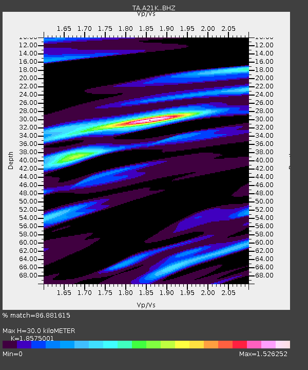
| Estimated Moho Depth: |
30.0 km |
| Estimated Crust Vp/Vs: |
1.86 |
| Assumed Crust Vp: |
6.048 km/s |
| Estimated Crust Vs: |
3.256 km/s |
| Estimated Crust Poisson's Ratio: |
0.30 |
|
| Radial Match: |
86.881615 % |
| Radial Bump: |
400 |
| Transverse Match: |
76.31379 % |
| Transverse Bump: |
400 |
| SOD ConfigId: |
20358551 |
| Insert Time: |
2019-12-28 05:12:05.058 +0000 |
| GWidth: |
2.5 |
| Max Bumps: |
400 |
| Tol: |
0.001 |
|

Signal To Noise
| Channel | StoN | STA | LTA |
| TA:A21K: :BHZ:20191214T05:09:58.125007Z | 6.964444 | 1.2137476E-6 | 1.7427773E-7 |
| TA:A21K: :BHN:20191214T05:09:58.125007Z | 2.4673011 | 4.8980945E-7 | 1.9852034E-7 |
| TA:A21K: :BHE:20191214T05:09:58.125007Z | 1.6814939 | 2.866255E-7 | 1.7045883E-7 |
| Arrivals |
| Ps | 4.3 SECOND |
| PpPs | 14 SECOND |
| PsPs/PpSs | 18 SECOND |


