You are here: Home > Network List > TA - USArray Transportable Network (new EarthScope stations) Stations List
> Station D25K Kavik River, AK, USA > Earthquake Result Viewer
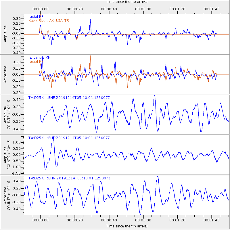
D25K Kavik River, AK, USA - Earthquake Result Viewer
*The percent match for this event was below the threshold and hence no stack was calculated.
| Earthquake location: |
Vanuatu Islands |
| Earthquake latitude/longitude: |
-14.4/167.7 |
| Earthquake time(UTC): |
2019/12/14 (348) 04:57:37 GMT |
| Earthquake Depth: |
27 km |
| Earthquake Magnitude: |
5.9 Mww |
| Earthquake Catalog/Contributor: |
NEIC PDE/us |
|
| Network: |
TA USArray Transportable Network (new EarthScope stations) |
| Station: |
D25K Kavik River, AK, USA |
| Lat/Lon: |
69.32 N/146.38 W |
| Elevation: |
770 m |
|
| Distance: |
89.5 deg |
| Az: |
14.788 deg |
| Baz: |
224.126 deg |
| Ray Param: |
$rayparam |
*The percent match for this event was below the threshold and hence was not used in the summary stack. |
|
| Radial Match: |
73.59049 % |
| Radial Bump: |
390 |
| Transverse Match: |
70.89324 % |
| Transverse Bump: |
372 |
| SOD ConfigId: |
20358551 |
| Insert Time: |
2019-12-28 05:12:16.964 +0000 |
| GWidth: |
2.5 |
| Max Bumps: |
400 |
| Tol: |
0.001 |
|
Signal To Noise
| Channel | StoN | STA | LTA |
| TA:D25K: :BHZ:20191214T05:10:01.125007Z | 3.614028 | 6.468208E-7 | 1.7897504E-7 |
| TA:D25K: :BHN:20191214T05:10:01.125007Z | 1.1102076 | 1.7203331E-7 | 1.54956E-7 |
| TA:D25K: :BHE:20191214T05:10:01.125007Z | 1.7192899 | 2.5815487E-7 | 1.5015203E-7 |
| Arrivals |
| Ps | |
| PpPs | |
| PsPs/PpSs | |


