You are here: Home > Network List > MN - MEDNET Project Stations List
> Station AQU L'Aquila, Italy > Earthquake Result Viewer
AQU L'Aquila, Italy - Earthquake Result Viewer
| Earthquake location: |
Southern India |
| Earthquake latitude/longitude: |
23.1/80.0 |
| Earthquake time(UTC): |
1997/05/21 (141) 22:51:28 GMT |
| Earthquake Depth: |
36 km |
| Earthquake Magnitude: |
6.0 MB, 5.6 MS, 5.8 UNKNOWN, 5.6 ME |
| Earthquake Catalog/Contributor: |
WHDF/NEIC |
|
| Network: |
MN MEDNET Project |
| Station: |
AQU L'Aquila, Italy |
| Lat/Lon: |
42.35 N/13.40 E |
| Elevation: |
710 m |
|
| Distance: |
57.8 deg |
| Az: |
306.501 deg |
| Baz: |
87.032 deg |
| Ray Param: |
0.063171476 |
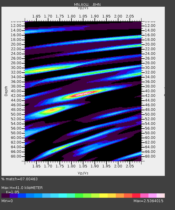
| Estimated Moho Depth: |
41.0 km |
| Estimated Crust Vp/Vs: |
1.85 |
| Assumed Crust Vp: |
6.276 km/s |
| Estimated Crust Vs: |
3.392 km/s |
| Estimated Crust Poisson's Ratio: |
0.29 |
|
| Radial Match: |
87.80463 % |
| Radial Bump: |
400 |
| Transverse Match: |
82.97979 % |
| Transverse Bump: |
400 |
| SOD ConfigId: |
6273 |
| Insert Time: |
2010-03-08 16:34:47.897 +0000 |
| GWidth: |
2.5 |
| Max Bumps: |
400 |
| Tol: |
0.001 |
|
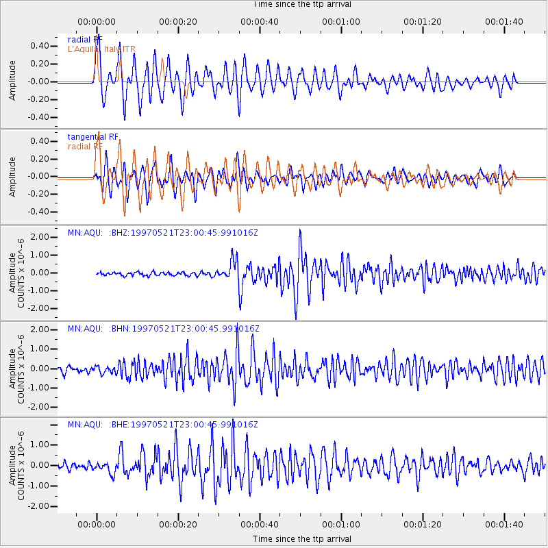
Signal To Noise
| Channel | StoN | STA | LTA |
| MN:AQU: :BHN:19970521T23:00:45.991016Z | 1.2766141 | 1.7294443E-7 | 1.3547118E-7 |
| MN:AQU: :BHE:19970521T23:00:45.991016Z | 1.9131159 | 2.7755365E-7 | 1.4507938E-7 |
| MN:AQU: :BHZ:19970521T23:00:45.991016Z | 6.1021605 | 5.4472105E-7 | 8.926692E-8 |
| Arrivals |
| Ps | 5.8 SECOND |
| PpPs | 18 SECOND |
| PsPs/PpSs | 24 SECOND |


