You are here: Home > Network List > TA - USArray Transportable Network (new EarthScope stations) Stations List
> Station F21K Alatna River, AK, USA > Earthquake Result Viewer
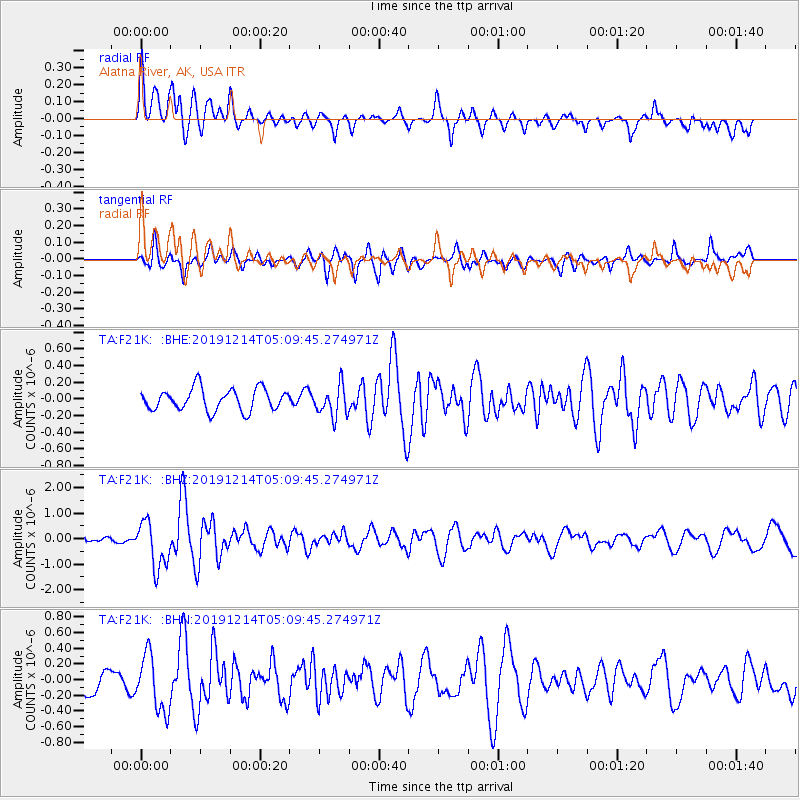
F21K Alatna River, AK, USA - Earthquake Result Viewer
*The percent match for this event was below the threshold and hence no stack was calculated.
| Earthquake location: |
Vanuatu Islands |
| Earthquake latitude/longitude: |
-14.4/167.7 |
| Earthquake time(UTC): |
2019/12/14 (348) 04:57:37 GMT |
| Earthquake Depth: |
27 km |
| Earthquake Magnitude: |
5.9 Mww |
| Earthquake Catalog/Contributor: |
NEIC PDE/us |
|
| Network: |
TA USArray Transportable Network (new EarthScope stations) |
| Station: |
F21K Alatna River, AK, USA |
| Lat/Lon: |
67.22 N/153.48 W |
| Elevation: |
597 m |
|
| Distance: |
86.2 deg |
| Az: |
14.162 deg |
| Baz: |
217.503 deg |
| Ray Param: |
$rayparam |
*The percent match for this event was below the threshold and hence was not used in the summary stack. |
|
| Radial Match: |
69.41871 % |
| Radial Bump: |
400 |
| Transverse Match: |
66.797325 % |
| Transverse Bump: |
400 |
| SOD ConfigId: |
20358551 |
| Insert Time: |
2019-12-28 05:12:29.520 +0000 |
| GWidth: |
2.5 |
| Max Bumps: |
400 |
| Tol: |
0.001 |
|
Signal To Noise
| Channel | StoN | STA | LTA |
| TA:F21K: :BHZ:20191214T05:09:45.274971Z | 4.740287 | 9.1843594E-7 | 1.9375113E-7 |
| TA:F21K: :BHN:20191214T05:09:45.274971Z | 1.590023 | 3.618597E-7 | 2.2758141E-7 |
| TA:F21K: :BHE:20191214T05:09:45.274971Z | 1.4081005 | 1.8440136E-7 | 1.3095753E-7 |
| Arrivals |
| Ps | |
| PpPs | |
| PsPs/PpSs | |


