You are here: Home > Network List > TA - USArray Transportable Network (new EarthScope stations) Stations List
> Station G17K Kiwalik Mountain, AK, USA > Earthquake Result Viewer
G17K Kiwalik Mountain, AK, USA - Earthquake Result Viewer
| Earthquake location: |
Vanuatu Islands |
| Earthquake latitude/longitude: |
-14.4/167.7 |
| Earthquake time(UTC): |
2019/12/14 (348) 04:57:37 GMT |
| Earthquake Depth: |
27 km |
| Earthquake Magnitude: |
5.9 Mww |
| Earthquake Catalog/Contributor: |
NEIC PDE/us |
|
| Network: |
TA USArray Transportable Network (new EarthScope stations) |
| Station: |
G17K Kiwalik Mountain, AK, USA |
| Lat/Lon: |
65.50 N/160.65 W |
| Elevation: |
338 m |
|
| Distance: |
83.2 deg |
| Az: |
12.734 deg |
| Baz: |
210.809 deg |
| Ray Param: |
0.04634738 |
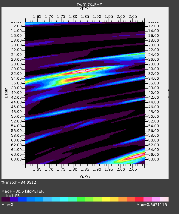
| Estimated Moho Depth: |
30.5 km |
| Estimated Crust Vp/Vs: |
1.85 |
| Assumed Crust Vp: |
6.276 km/s |
| Estimated Crust Vs: |
3.392 km/s |
| Estimated Crust Poisson's Ratio: |
0.29 |
|
| Radial Match: |
84.6512 % |
| Radial Bump: |
385 |
| Transverse Match: |
75.31722 % |
| Transverse Bump: |
318 |
| SOD ConfigId: |
20358551 |
| Insert Time: |
2019-12-28 05:12:33.303 +0000 |
| GWidth: |
2.5 |
| Max Bumps: |
400 |
| Tol: |
0.001 |
|

Signal To Noise
| Channel | StoN | STA | LTA |
| TA:G17K: :BHZ:20191214T05:09:29.95002Z | 8.6933565 | 1.5162749E-6 | 1.7441765E-7 |
| TA:G17K: :BHN:20191214T05:09:29.95002Z | 2.5455618 | 5.064758E-7 | 1.9896427E-7 |
| TA:G17K: :BHE:20191214T05:09:29.95002Z | 1.6967952 | 3.5805002E-7 | 2.1101545E-7 |
| Arrivals |
| Ps | 4.2 SECOND |
| PpPs | 14 SECOND |
| PsPs/PpSs | 18 SECOND |


