You are here: Home > Network List > MN - MEDNET Project Stations List
> Station AQU L'Aquila, Italy > Earthquake Result Viewer
AQU L'Aquila, Italy - Earthquake Result Viewer
| Earthquake location: |
Kyushu, Japan |
| Earthquake latitude/longitude: |
31.0/130.0 |
| Earthquake time(UTC): |
2005/11/21 (325) 15:36:30 GMT |
| Earthquake Depth: |
145 km |
| Earthquake Magnitude: |
5.9 MB, 6.2 MW, 6.2 MW |
| Earthquake Catalog/Contributor: |
WHDF/NEIC |
|
| Network: |
MN MEDNET Project |
| Station: |
AQU L'Aquila, Italy |
| Lat/Lon: |
42.35 N/13.40 E |
| Elevation: |
710 m |
|
| Distance: |
86.6 deg |
| Az: |
318.394 deg |
| Baz: |
50.269 deg |
| Ray Param: |
0.043608427 |
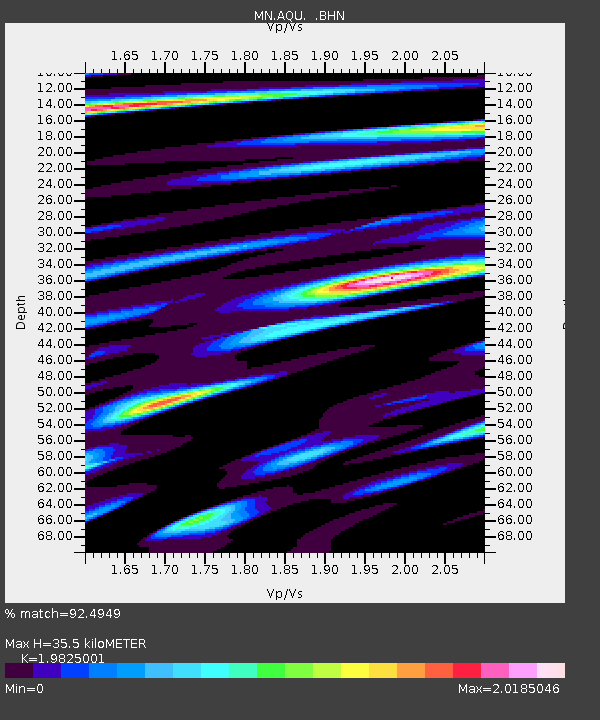
| Estimated Moho Depth: |
35.5 km |
| Estimated Crust Vp/Vs: |
1.98 |
| Assumed Crust Vp: |
6.276 km/s |
| Estimated Crust Vs: |
3.166 km/s |
| Estimated Crust Poisson's Ratio: |
0.33 |
|
| Radial Match: |
92.4949 % |
| Radial Bump: |
400 |
| Transverse Match: |
85.12119 % |
| Transverse Bump: |
400 |
| SOD ConfigId: |
2448 |
| Insert Time: |
2010-03-08 16:35:25.085 +0000 |
| GWidth: |
2.5 |
| Max Bumps: |
400 |
| Tol: |
0.001 |
|

Signal To Noise
| Channel | StoN | STA | LTA |
| MN:AQU: :BHN:20051121T15:48:26.776021Z | 4.7093616 | 8.0782587E-7 | 1.7153617E-7 |
| MN:AQU: :BHE:20051121T15:48:26.776021Z | 4.8682904 | 7.5522547E-7 | 1.5513156E-7 |
| MN:AQU: :BHZ:20051121T15:48:26.776021Z | 31.518894 | 3.0304398E-6 | 9.614676E-8 |
| Arrivals |
| Ps | 5.7 SECOND |
| PpPs | 17 SECOND |
| PsPs/PpSs | 22 SECOND |


