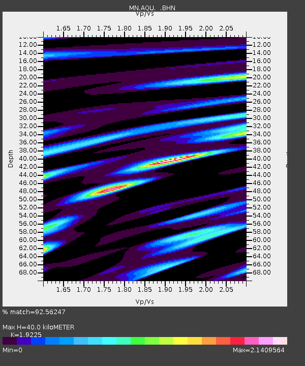
AQU L'Aquila, Italy - Earthquake Result Viewer
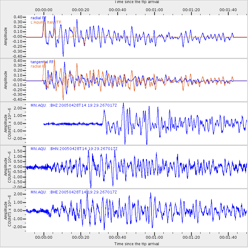
Earthquake location: Northern Sumatra, Indonesia
Earthquake latitude/longitude: 2.1/96.8
Earthquake time(UTC): 2005/04/28 (118) 14:07:33 GMT
Earthquake Depth: 22 km
Earthquake Magnitude: 5.9 MB, 6.2 MS, 6.3 MW, 6.2 MW
Earthquake Catalog/Contributor: WHDF/NEIC
Network: MN MEDNET Project
Station: AQU L'Aquila, Italy
Lat/Lon: 42.35 N/13.40 E
Elevation: 710 m
Distance: 83.7 deg
Az: 312.199 deg
Baz: 92.871 deg
Ray Param: 0.04599146
Estimated Moho Depth: 40.0 km
Estimated Crust Vp/Vs: 1.92
Assumed Crust Vp: 6.276 km/s
Estimated Crust Vs: 3.264 km/s
Estimated Crust Poisson's Ratio: 0.31
Radial Match: 92.56247 %
Radial Bump: 400
Transverse Match: 92.42361 %
Transverse Bump: 400
SOD ConfigId: 2459
Insert Time: 2010-03-08 16:35:38.231 +0000
GWidth: 2.5
Max Bumps: 400
Tol: 0.001

Signal To Noise

ChannelStoNSTALTA
MN:AQU: :BHN:20050428T14:19:29.267017Z1.12568971.3849596E-71.230321E-7
MN:AQU: :BHE:20050428T14:19:29.267017Z2.10824283.0716996E-71.4569952E-7
MN:AQU: :BHZ:20050428T14:19:29.267017Z11.2053217.3454873E-76.5553564E-8
Arrivals
Ps6.0 SECOND
PpPs18 SECOND
PsPs/PpSs24 SECOND