You are here: Home > Network List > AK - Alaska Regional Network Stations List
> Station TGL Tana Glacier > Earthquake Result Viewer
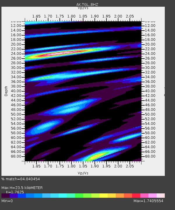
TGL Tana Glacier - Earthquake Result Viewer
| Earthquake location: |
Mindanao, Philippines |
| Earthquake latitude/longitude: |
6.7/125.2 |
| Earthquake time(UTC): |
2019/12/15 (349) 06:11:52 GMT |
| Earthquake Depth: |
22 km |
| Earthquake Magnitude: |
6.8 mww |
| Earthquake Catalog/Contributor: |
NEIC PDE/us |
|
| Network: |
AK Alaska Regional Network |
| Station: |
TGL Tana Glacier |
| Lat/Lon: |
60.75 N/142.83 W |
| Elevation: |
1260 m |
|
| Distance: |
85.2 deg |
| Az: |
29.506 deg |
| Baz: |
275.005 deg |
| Ray Param: |
0.044934396 |
| Estimated Moho Depth: |
23.5 km |
| Estimated Crust Vp/Vs: |
1.76 |
| Assumed Crust Vp: |
6.566 km/s |
| Estimated Crust Vs: |
3.725 km/s |
| Estimated Crust Poisson's Ratio: |
0.26 |
|
| Radial Match: |
84.840454 % |
| Radial Bump: |
393 |
| Transverse Match: |
76.41863 % |
| Transverse Bump: |
355 |
| SOD ConfigId: |
20358551 |
| Insert Time: |
2019-12-29 06:23:15.439 +0000 |
| GWidth: |
2.5 |
| Max Bumps: |
400 |
| Tol: |
0.001 |
|

Signal To Noise
| Channel | StoN | STA | LTA |
| AK:TGL: :BHZ:20191215T06:23:55.047995Z | 2.0154593 | 8.2571194E-7 | 4.096892E-7 |
| AK:TGL: :BHN:20191215T06:23:55.047995Z | 2.0850313 | 7.951232E-7 | 3.8134834E-7 |
| AK:TGL: :BHE:20191215T06:23:55.047995Z | 1.4455152 | 4.1678516E-7 | 2.8832983E-7 |
| Arrivals |
| Ps | 2.8 SECOND |
| PpPs | 9.6 SECOND |
| PsPs/PpSs | 12 SECOND |


