You are here: Home > Network List > MN - MEDNET Project Stations List
> Station AQU L'Aquila, Italy > Earthquake Result Viewer
AQU L'Aquila, Italy - Earthquake Result Viewer
| Earthquake location: |
East Of Kuril Islands |
| Earthquake latitude/longitude: |
46.2/154.5 |
| Earthquake time(UTC): |
2007/01/13 (013) 04:23:21 GMT |
| Earthquake Depth: |
10 km |
| Earthquake Magnitude: |
7.3 MB, 8.2 MS, 8.1 MW, 7.9 MW |
| Earthquake Catalog/Contributor: |
WHDF/NEIC |
|
| Network: |
MN MEDNET Project |
| Station: |
AQU L'Aquila, Italy |
| Lat/Lon: |
42.35 N/13.40 E |
| Elevation: |
710 m |
|
| Distance: |
85.3 deg |
| Az: |
332.168 deg |
| Baz: |
25.922 deg |
| Ray Param: |
0.044898733 |
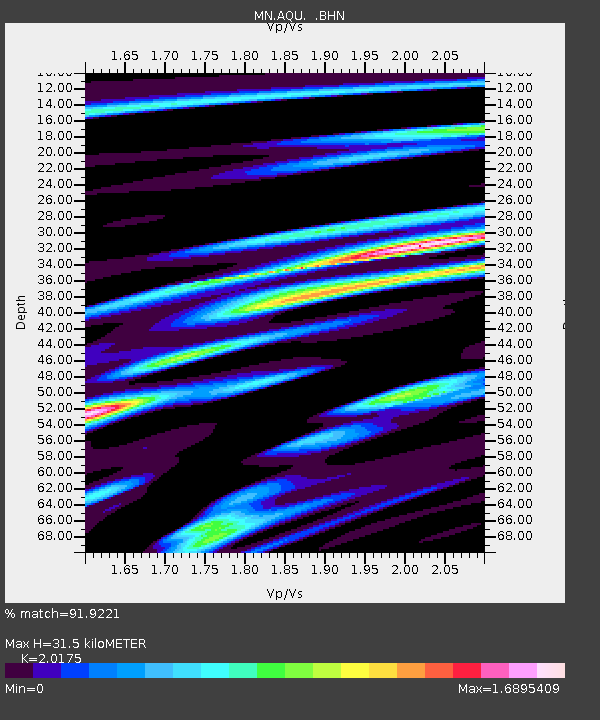
| Estimated Moho Depth: |
31.5 km |
| Estimated Crust Vp/Vs: |
2.02 |
| Assumed Crust Vp: |
6.276 km/s |
| Estimated Crust Vs: |
3.111 km/s |
| Estimated Crust Poisson's Ratio: |
0.34 |
|
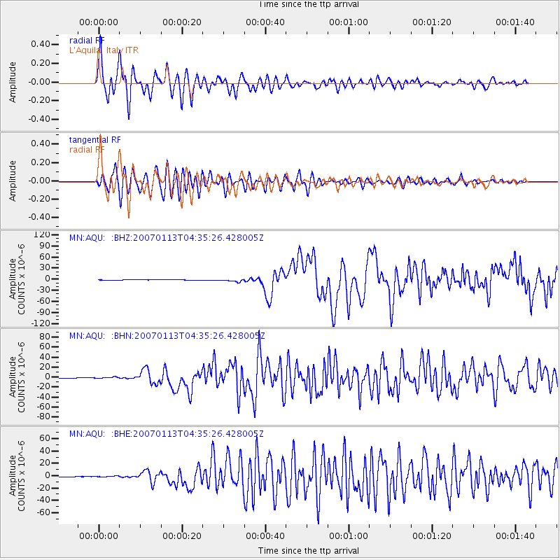
| Radial Match: |
91.9221 % |
| Radial Bump: |
400 |
| Transverse Match: |
91.44406 % |
| Transverse Bump: |
400 |
| SOD ConfigId: |
2564 |
| Insert Time: |
2010-03-08 16:36:26.727 +0000 |
| GWidth: |
2.5 |
| Max Bumps: |
400 |
| Tol: |
0.001 |
|
Signal To Noise
| Channel | StoN | STA | LTA |
| MN:AQU: :BHN:20070113T04:35:26.428005Z | 5.0512753 | 1.5198257E-6 | 3.008796E-7 |
| MN:AQU: :BHE:20070113T04:35:26.428005Z | 4.3376017 | 1.0110335E-6 | 2.3308586E-7 |
| MN:AQU: :BHZ:20070113T04:35:26.428005Z | 12.726468 | 3.5601531E-6 | 2.79744E-7 |
| Arrivals |
| Ps | 5.2 SECOND |
| PpPs | 15 SECOND |
| PsPs/PpSs | 20 SECOND |


