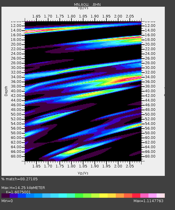
AQU L'Aquila, Italy - Earthquake Result Viewer
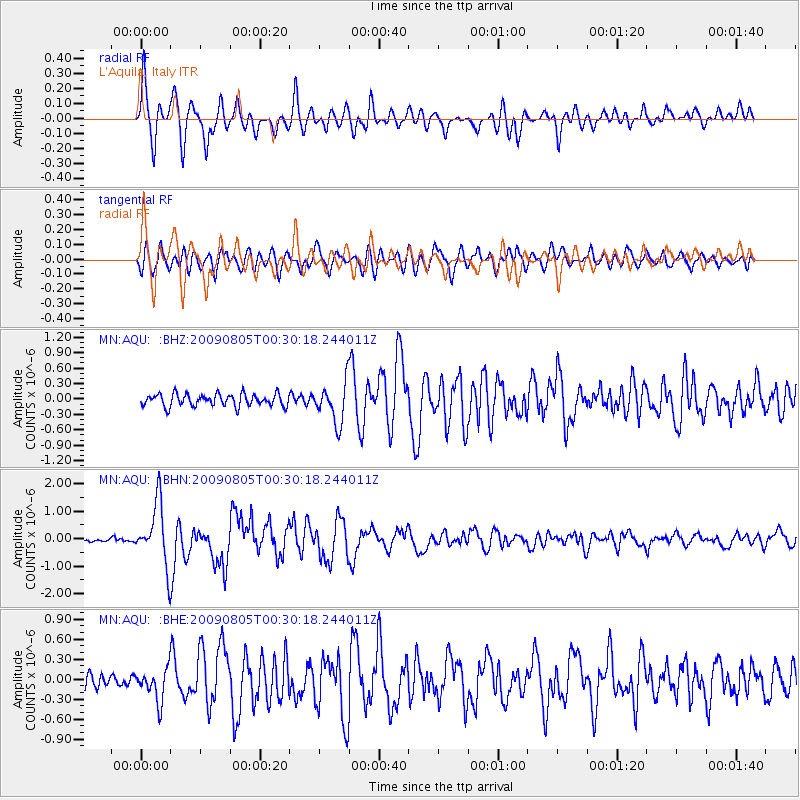
Earthquake location: Southwestern Ryukyu Isl., Japan
Earthquake latitude/longitude: 24.2/125.1
Earthquake time(UTC): 2009/08/05 (217) 00:17:58 GMT
Earthquake Depth: 25 km
Earthquake Magnitude: 5.9 MB, 5.9 MS, 6.2 MW, 6.1 MW
Earthquake Catalog/Contributor: WHDF/NEIC
Network: MN MEDNET Project
Station: AQU L'Aquila, Italy
Lat/Lon: 42.35 N/13.40 E
Elevation: 710 m
Distance: 88.6 deg
Az: 316.452 deg
Baz: 58.051 deg
Ray Param: 0.04241538
Estimated Moho Depth: 14.25 km
Estimated Crust Vp/Vs: 1.61
Assumed Crust Vp: 6.276 km/s
Estimated Crust Vs: 3.904 km/s
Estimated Crust Poisson's Ratio: 0.18
Radial Match: 88.27185 %
Radial Bump: 400
Transverse Match: 75.40963 %
Transverse Bump: 400
SOD ConfigId: 2622
Insert Time: 2010-03-08 16:36:29.721 +0000
GWidth: 2.5
Max Bumps: 400
Tol: 0.001

Signal To Noise

ChannelStoNSTALTA
MN:AQU: :BHN:20090805T00:30:18.244011Z17.630971.1304596E-66.4117835E-8
MN:AQU: :BHE:20090805T00:30:18.244011Z1.75056292.4337186E-71.390249E-7
MN:AQU: :BHZ:20090805T00:30:18.244011Z3.28130153.892497E-71.18626616E-7
Arrivals
Ps1.4 SECOND
PpPs5.8 SECOND
PsPs/PpSs7.2 SECOND