You are here: Home > Network List > IU - Global Seismograph Network (GSN - IRIS/USGS) Stations List
> Station POHA Pohakuloa, Hawaii, USA > Earthquake Result Viewer
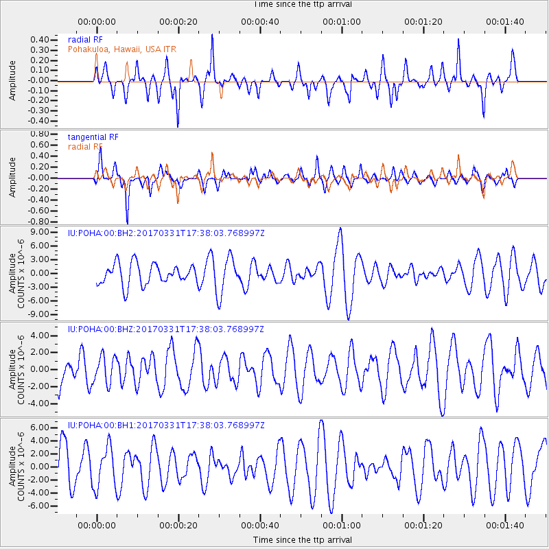
POHA Pohakuloa, Hawaii, USA - Earthquake Result Viewer
*The percent match for this event was below the threshold and hence no stack was calculated.
| Earthquake location: |
Reykjanes Ridge |
| Earthquake latitude/longitude: |
52.7/-32.3 |
| Earthquake time(UTC): |
2017/03/31 (090) 17:25:23 GMT |
| Earthquake Depth: |
10 km |
| Earthquake Magnitude: |
5.5 Mww |
| Earthquake Catalog/Contributor: |
NEIC PDE/us |
|
| Network: |
IU Global Seismograph Network (GSN - IRIS/USGS) |
| Station: |
POHA Pohakuloa, Hawaii, USA |
| Lat/Lon: |
19.76 N/155.53 W |
| Elevation: |
1990 m |
|
| Distance: |
92.7 deg |
| Az: |
307.924 deg |
| Baz: |
30.664 deg |
| Ray Param: |
$rayparam |
*The percent match for this event was below the threshold and hence was not used in the summary stack. |
|
| Radial Match: |
48.695515 % |
| Radial Bump: |
378 |
| Transverse Match: |
57.51139 % |
| Transverse Bump: |
400 |
| SOD ConfigId: |
2028011 |
| Insert Time: |
2017-04-14 17:28:54.231 +0000 |
| GWidth: |
2.5 |
| Max Bumps: |
400 |
| Tol: |
0.001 |
|
Signal To Noise
| Channel | StoN | STA | LTA |
| IU:POHA:00:BHZ:20170331T17:38:03.768997Z | 0.61591786 | 1.6060567E-6 | 2.6075827E-6 |
| IU:POHA:00:BH1:20170331T17:38:03.768997Z | 0.908898 | 3.2039518E-6 | 3.5250948E-6 |
| IU:POHA:00:BH2:20170331T17:38:03.768997Z | 1.8296226 | 4.133016E-6 | 2.2589445E-6 |
| Arrivals |
| Ps | |
| PpPs | |
| PsPs/PpSs | |


