You are here: Home > Network List > TA - USArray Transportable Network (new EarthScope stations) Stations List
> Station B22K Teshekpuk Lake, AK, USA > Earthquake Result Viewer
B22K Teshekpuk Lake, AK, USA - Earthquake Result Viewer
| Earthquake location: |
Mindanao, Philippines |
| Earthquake latitude/longitude: |
6.7/125.2 |
| Earthquake time(UTC): |
2019/12/15 (349) 06:11:52 GMT |
| Earthquake Depth: |
22 km |
| Earthquake Magnitude: |
6.8 mww |
| Earthquake Catalog/Contributor: |
NEIC PDE/us |
|
| Network: |
TA USArray Transportable Network (new EarthScope stations) |
| Station: |
B22K Teshekpuk Lake, AK, USA |
| Lat/Lon: |
70.34 N/153.42 W |
| Elevation: |
50 m |
|
| Distance: |
80.8 deg |
| Az: |
19.814 deg |
| Baz: |
264.15 deg |
| Ray Param: |
0.047993626 |
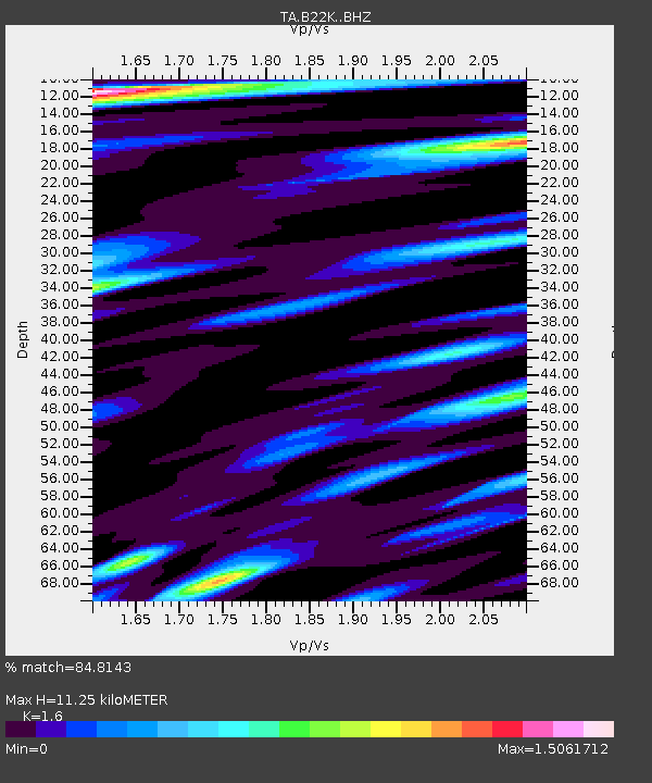
| Estimated Moho Depth: |
11.25 km |
| Estimated Crust Vp/Vs: |
1.60 |
| Assumed Crust Vp: |
5.738 km/s |
| Estimated Crust Vs: |
3.586 km/s |
| Estimated Crust Poisson's Ratio: |
0.18 |
|
| Radial Match: |
84.8143 % |
| Radial Bump: |
400 |
| Transverse Match: |
79.13537 % |
| Transverse Bump: |
400 |
| SOD ConfigId: |
20358551 |
| Insert Time: |
2019-12-29 06:26:15.453 +0000 |
| GWidth: |
2.5 |
| Max Bumps: |
400 |
| Tol: |
0.001 |
|
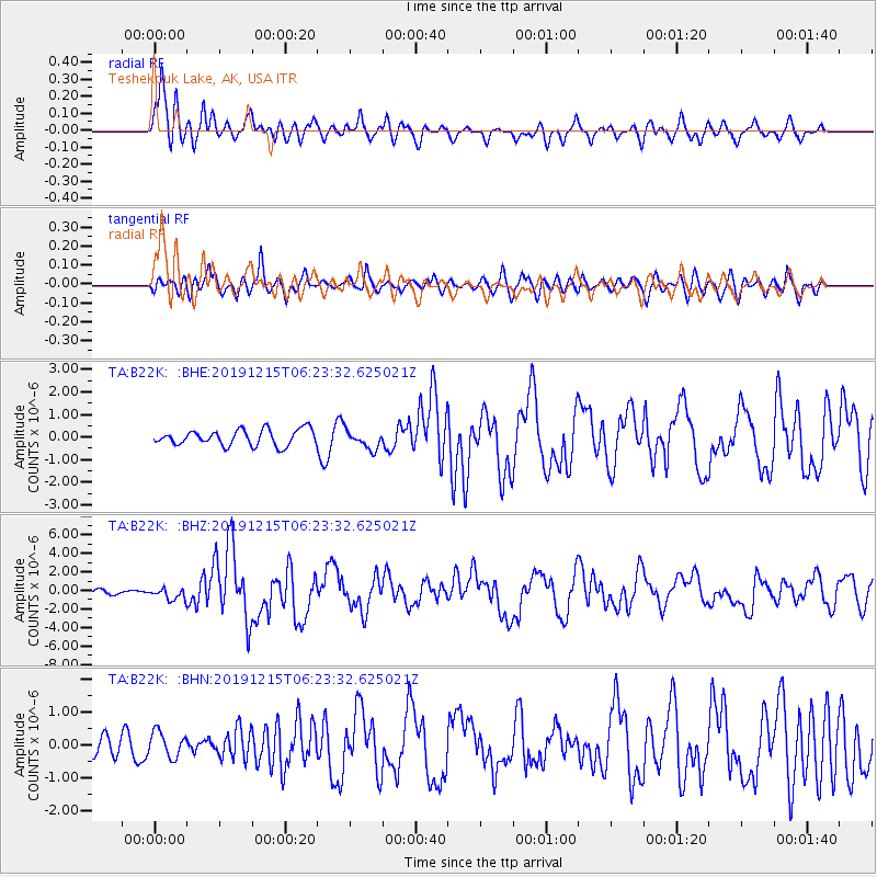
Signal To Noise
| Channel | StoN | STA | LTA |
| TA:B22K: :BHZ:20191215T06:23:32.625021Z | 2.3569784 | 6.383424E-7 | 2.708308E-7 |
| TA:B22K: :BHN:20191215T06:23:32.625021Z | 0.82016927 | 3.8129156E-7 | 4.648937E-7 |
| TA:B22K: :BHE:20191215T06:23:32.625021Z | 1.1813637 | 4.101974E-7 | 3.4722365E-7 |
| Arrivals |
| Ps | 1.2 SECOND |
| PpPs | 5.0 SECOND |
| PsPs/PpSs | 6.2 SECOND |


