You are here: Home > Network List > TA - USArray Transportable Network (new EarthScope stations) Stations List
> Station D23K Nanushuk River, AK USA > Earthquake Result Viewer
D23K Nanushuk River, AK USA - Earthquake Result Viewer

| Earthquake location: |
Mindanao, Philippines |
| Earthquake latitude/longitude: |
6.7/125.2 |
| Earthquake time(UTC): |
2019/12/15 (349) 06:11:52 GMT |
| Earthquake Depth: |
22 km |
| Earthquake Magnitude: |
6.8 mww |
| Earthquake Catalog/Contributor: |
NEIC PDE/us |
|
| Network: |
TA USArray Transportable Network (new EarthScope stations) |
| Station: |
D23K Nanushuk River, AK USA |
| Lat/Lon: |
68.97 N/150.68 W |
| Elevation: |
406 m |
|
| Distance: |
81.7 deg |
| Az: |
21.283 deg |
| Baz: |
266.94 deg |
| Ray Param: |
0.04740056 |
| Estimated Moho Depth: |
12.5 km |
| Estimated Crust Vp/Vs: |
1.81 |
| Assumed Crust Vp: |
6.221 km/s |
| Estimated Crust Vs: |
3.447 km/s |
| Estimated Crust Poisson's Ratio: |
0.28 |
|
| Radial Match: |
82.72324 % |
| Radial Bump: |
400 |
| Transverse Match: |
76.693085 % |
| Transverse Bump: |
400 |
| SOD ConfigId: |
20358551 |
| Insert Time: |
2019-12-29 06:26:22.173 +0000 |
| GWidth: |
2.5 |
| Max Bumps: |
400 |
| Tol: |
0.001 |
|
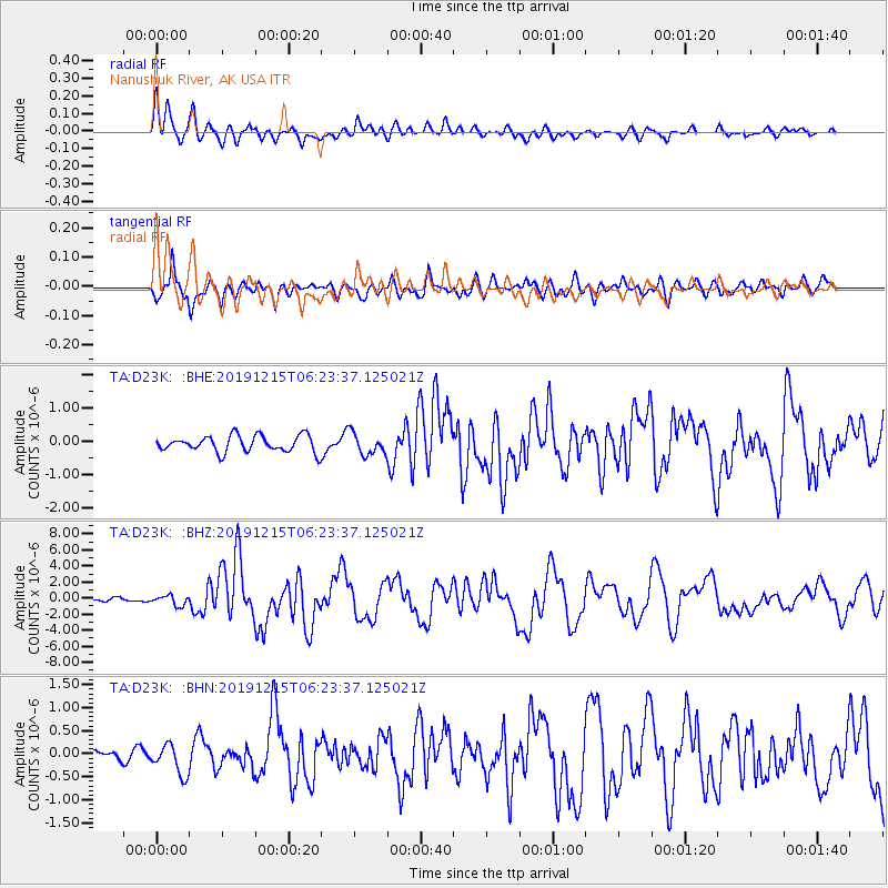
Signal To Noise
| Channel | StoN | STA | LTA |
| TA:D23K: :BHZ:20191215T06:23:37.125021Z | 2.5281239 | 6.1577316E-7 | 2.4356922E-7 |
| TA:D23K: :BHN:20191215T06:23:37.125021Z | 1.4518032 | 3.2639295E-7 | 2.2481899E-7 |
| TA:D23K: :BHE:20191215T06:23:37.125021Z | 1.3410971 | 3.2453966E-7 | 2.4199562E-7 |
| Arrivals |
| Ps | 1.7 SECOND |
| PpPs | 5.5 SECOND |
| PsPs/PpSs | 7.2 SECOND |


