You are here: Home > Network List > TA - USArray Transportable Network (new EarthScope stations) Stations List
> Station E20K Nigu River, AK, USA > Earthquake Result Viewer
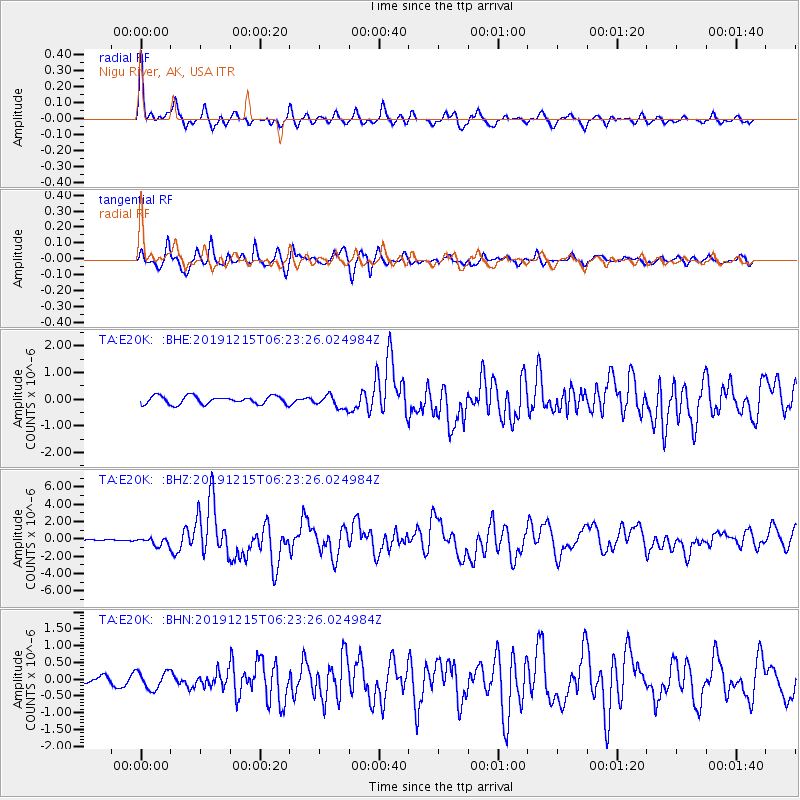
E20K Nigu River, AK, USA - Earthquake Result Viewer

| Earthquake location: |
Mindanao, Philippines |
| Earthquake latitude/longitude: |
6.7/125.2 |
| Earthquake time(UTC): |
2019/12/15 (349) 06:11:52 GMT |
| Earthquake Depth: |
22 km |
| Earthquake Magnitude: |
6.8 mww |
| Earthquake Catalog/Contributor: |
NEIC PDE/us |
|
| Network: |
TA USArray Transportable Network (new EarthScope stations) |
| Station: |
E20K Nigu River, AK, USA |
| Lat/Lon: |
68.26 N/156.19 W |
| Elevation: |
866 m |
|
| Distance: |
79.6 deg |
| Az: |
21.801 deg |
| Baz: |
261.9 deg |
| Ray Param: |
0.048832916 |
| Estimated Moho Depth: |
33.0 km |
| Estimated Crust Vp/Vs: |
2.09 |
| Assumed Crust Vp: |
6.221 km/s |
| Estimated Crust Vs: |
2.973 km/s |
| Estimated Crust Poisson's Ratio: |
0.35 |
|
| Radial Match: |
83.651726 % |
| Radial Bump: |
400 |
| Transverse Match: |
89.001884 % |
| Transverse Bump: |
400 |
| SOD ConfigId: |
20358551 |
| Insert Time: |
2019-12-29 06:26:26.372 +0000 |
| GWidth: |
2.5 |
| Max Bumps: |
400 |
| Tol: |
0.001 |
|
Signal To Noise
| Channel | StoN | STA | LTA |
| TA:E20K: :BHZ:20191215T06:23:26.024984Z | 2.6375837 | 4.4670304E-7 | 1.6936072E-7 |
| TA:E20K: :BHN:20191215T06:23:26.024984Z | 2.388555 | 2.640079E-7 | 1.1053038E-7 |
| TA:E20K: :BHE:20191215T06:23:26.024984Z | 1.6375452 | 2.4791376E-7 | 1.5139354E-7 |
| Arrivals |
| Ps | 5.9 SECOND |
| PpPs | 16 SECOND |
| PsPs/PpSs | 22 SECOND |


