You are here: Home > Network List > TA - USArray Transportable Network (new EarthScope stations) Stations List
> Station F21K Alatna River, AK, USA > Earthquake Result Viewer
F21K Alatna River, AK, USA - Earthquake Result Viewer
| Earthquake location: |
Mindanao, Philippines |
| Earthquake latitude/longitude: |
6.7/125.2 |
| Earthquake time(UTC): |
2019/12/15 (349) 06:11:52 GMT |
| Earthquake Depth: |
22 km |
| Earthquake Magnitude: |
6.8 mww |
| Earthquake Catalog/Contributor: |
NEIC PDE/us |
|
| Network: |
TA USArray Transportable Network (new EarthScope stations) |
| Station: |
F21K Alatna River, AK, USA |
| Lat/Lon: |
67.22 N/153.48 W |
| Elevation: |
597 m |
|
| Distance: |
80.5 deg |
| Az: |
22.972 deg |
| Baz: |
264.604 deg |
| Ray Param: |
0.04821653 |
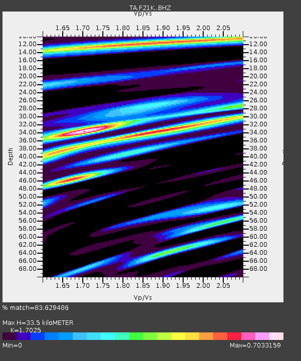
| Estimated Moho Depth: |
33.5 km |
| Estimated Crust Vp/Vs: |
1.70 |
| Assumed Crust Vp: |
6.455 km/s |
| Estimated Crust Vs: |
3.792 km/s |
| Estimated Crust Poisson's Ratio: |
0.24 |
|
| Radial Match: |
83.629486 % |
| Radial Bump: |
400 |
| Transverse Match: |
66.843925 % |
| Transverse Bump: |
400 |
| SOD ConfigId: |
20358551 |
| Insert Time: |
2019-12-29 06:26:35.554 +0000 |
| GWidth: |
2.5 |
| Max Bumps: |
400 |
| Tol: |
0.001 |
|
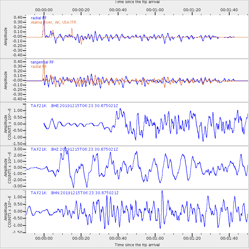
Signal To Noise
| Channel | StoN | STA | LTA |
| TA:F21K: :BHZ:20191215T06:23:30.875021Z | 2.9179707 | 3.2813244E-7 | 1.1245228E-7 |
| TA:F21K: :BHN:20191215T06:23:30.875021Z | 0.79324144 | 1.4691878E-7 | 1.8521318E-7 |
| TA:F21K: :BHE:20191215T06:23:30.875021Z | 1.1968207 | 1.855131E-7 | 1.5500491E-7 |
| Arrivals |
| Ps | 3.8 SECOND |
| PpPs | 14 SECOND |
| PsPs/PpSs | 17 SECOND |


