You are here: Home > Network List > TA - USArray Transportable Network (new EarthScope stations) Stations List
> Station G17K Kiwalik Mountain, AK, USA > Earthquake Result Viewer
G17K Kiwalik Mountain, AK, USA - Earthquake Result Viewer
| Earthquake location: |
Mindanao, Philippines |
| Earthquake latitude/longitude: |
6.7/125.2 |
| Earthquake time(UTC): |
2019/12/15 (349) 06:11:52 GMT |
| Earthquake Depth: |
22 km |
| Earthquake Magnitude: |
6.8 mww |
| Earthquake Catalog/Contributor: |
NEIC PDE/us |
|
| Network: |
TA USArray Transportable Network (new EarthScope stations) |
| Station: |
G17K Kiwalik Mountain, AK, USA |
| Lat/Lon: |
65.50 N/160.65 W |
| Elevation: |
338 m |
|
| Distance: |
77.4 deg |
| Az: |
24.273 deg |
| Baz: |
258.292 deg |
| Ray Param: |
0.05033937 |
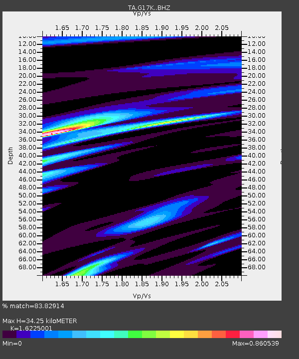
| Estimated Moho Depth: |
34.25 km |
| Estimated Crust Vp/Vs: |
1.62 |
| Assumed Crust Vp: |
6.276 km/s |
| Estimated Crust Vs: |
3.868 km/s |
| Estimated Crust Poisson's Ratio: |
0.19 |
|
| Radial Match: |
83.82914 % |
| Radial Bump: |
397 |
| Transverse Match: |
66.34631 % |
| Transverse Bump: |
400 |
| SOD ConfigId: |
20358551 |
| Insert Time: |
2019-12-29 06:26:40.205 +0000 |
| GWidth: |
2.5 |
| Max Bumps: |
400 |
| Tol: |
0.001 |
|

Signal To Noise
| Channel | StoN | STA | LTA |
| TA:G17K: :BHZ:20191215T06:23:13.849997Z | 2.4787357 | 4.3954998E-7 | 1.7732829E-7 |
| TA:G17K: :BHN:20191215T06:23:13.849997Z | 1.9735814 | 4.3078094E-7 | 2.1827371E-7 |
| TA:G17K: :BHE:20191215T06:23:13.849997Z | 1.239598 | 3.6066666E-7 | 2.9095452E-7 |
| Arrivals |
| Ps | 3.5 SECOND |
| PpPs | 14 SECOND |
| PsPs/PpSs | 17 SECOND |


