You are here: Home > Network List > US - United States National Seismic Network Stations List
> Station DGMT Dagmar, Montana, USA > Earthquake Result Viewer
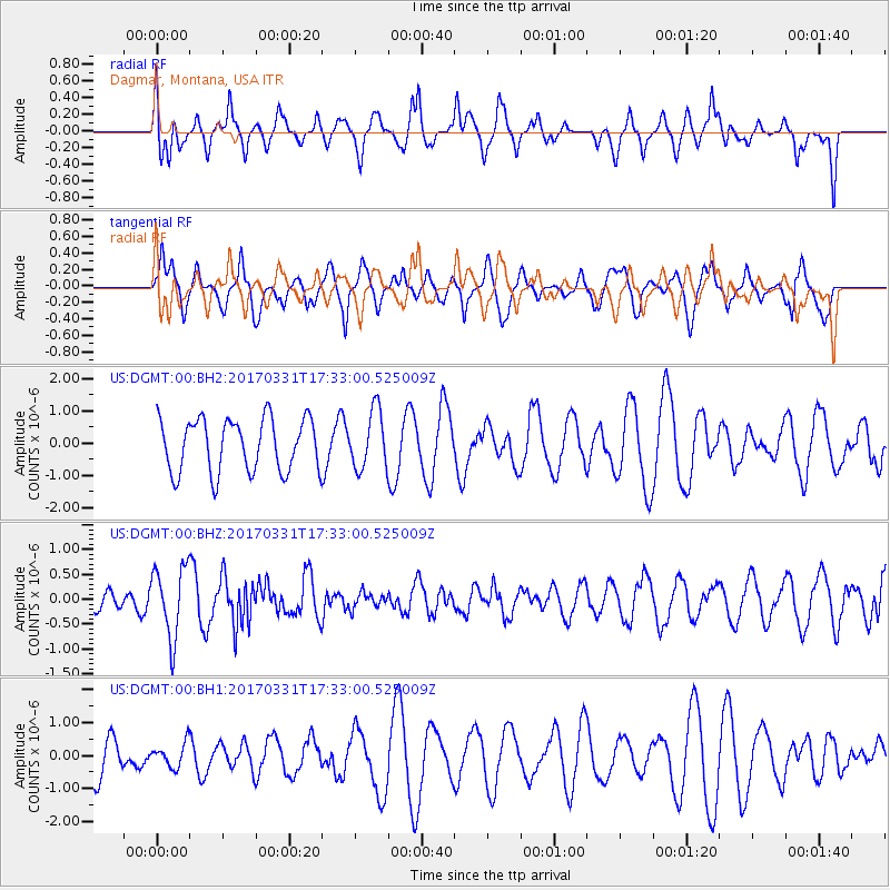
DGMT Dagmar, Montana, USA - Earthquake Result Viewer
*The percent match for this event was below the threshold and hence no stack was calculated.
| Earthquake location: |
Reykjanes Ridge |
| Earthquake latitude/longitude: |
52.7/-32.3 |
| Earthquake time(UTC): |
2017/03/31 (090) 17:25:23 GMT |
| Earthquake Depth: |
10 km |
| Earthquake Magnitude: |
5.5 Mww |
| Earthquake Catalog/Contributor: |
NEIC PDE/us |
|
| Network: |
US United States National Seismic Network |
| Station: |
DGMT Dagmar, Montana, USA |
| Lat/Lon: |
48.47 N/104.20 W |
| Elevation: |
0.0 m |
|
| Distance: |
44.1 deg |
| Az: |
294.658 deg |
| Baz: |
56.261 deg |
| Ray Param: |
$rayparam |
*The percent match for this event was below the threshold and hence was not used in the summary stack. |
|
| Radial Match: |
52.178017 % |
| Radial Bump: |
400 |
| Transverse Match: |
70.87701 % |
| Transverse Bump: |
400 |
| SOD ConfigId: |
2028011 |
| Insert Time: |
2017-04-14 17:30:40.693 +0000 |
| GWidth: |
2.5 |
| Max Bumps: |
400 |
| Tol: |
0.001 |
|
Signal To Noise
| Channel | StoN | STA | LTA |
| US:DGMT:00:BHZ:20170331T17:33:00.525009Z | 2.4444914 | 7.1338405E-7 | 2.9183332E-7 |
| US:DGMT:00:BH1:20170331T17:33:00.525009Z | 0.5018911 | 3.57347E-7 | 7.1200117E-7 |
| US:DGMT:00:BH2:20170331T17:33:00.525009Z | 1.0898875 | 8.944642E-7 | 8.206941E-7 |
| Arrivals |
| Ps | |
| PpPs | |
| PsPs/PpSs | |


