You are here: Home > Network List > TA - USArray Transportable Network (new EarthScope stations) Stations List
> Station R33M Jennings River, BC, CAN > Earthquake Result Viewer
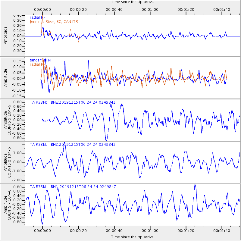
R33M Jennings River, BC, CAN - Earthquake Result Viewer
*The percent match for this event was below the threshold and hence no stack was calculated.
| Earthquake location: |
Mindanao, Philippines |
| Earthquake latitude/longitude: |
6.7/125.2 |
| Earthquake time(UTC): |
2019/12/15 (349) 06:11:52 GMT |
| Earthquake Depth: |
22 km |
| Earthquake Magnitude: |
6.8 mww |
| Earthquake Catalog/Contributor: |
NEIC PDE/us |
|
| Network: |
TA USArray Transportable Network (new EarthScope stations) |
| Station: |
R33M Jennings River, BC, CAN |
| Lat/Lon: |
59.39 N/130.97 W |
| Elevation: |
1437 m |
|
| Distance: |
91.3 deg |
| Az: |
29.796 deg |
| Baz: |
285.286 deg |
| Ray Param: |
$rayparam |
*The percent match for this event was below the threshold and hence was not used in the summary stack. |
|
| Radial Match: |
54.615055 % |
| Radial Bump: |
400 |
| Transverse Match: |
53.80339 % |
| Transverse Bump: |
400 |
| SOD ConfigId: |
20358551 |
| Insert Time: |
2019-12-29 06:27:03.107 +0000 |
| GWidth: |
2.5 |
| Max Bumps: |
400 |
| Tol: |
0.001 |
|
Signal To Noise
| Channel | StoN | STA | LTA |
| TA:R33M: :BHZ:20191215T06:24:24.024984Z | 0.9313797 | 3.2143086E-7 | 3.451126E-7 |
| TA:R33M: :BHN:20191215T06:24:24.024984Z | 2.051806 | 5.174046E-7 | 2.5217034E-7 |
| TA:R33M: :BHE:20191215T06:24:24.024984Z | 1.2813656 | 2.1090999E-7 | 1.6459782E-7 |
| Arrivals |
| Ps | |
| PpPs | |
| PsPs/PpSs | |


