You are here: Home > Network List > G - GEOSCOPE Stations List
> Station MPG Montagne des Peres, French Guyana > Earthquake Result Viewer
MPG Montagne des Peres, French Guyana - Earthquake Result Viewer
| Earthquake location: |
Botswana |
| Earthquake latitude/longitude: |
-22.7/25.1 |
| Earthquake time(UTC): |
2017/04/03 (093) 17:40:18 GMT |
| Earthquake Depth: |
29 km |
| Earthquake Magnitude: |
6.5 Mww |
| Earthquake Catalog/Contributor: |
NEIC PDE/us |
|
| Network: |
G GEOSCOPE |
| Station: |
MPG Montagne des Peres, French Guyana |
| Lat/Lon: |
5.11 N/52.64 W |
| Elevation: |
147 m |
|
| Distance: |
80.8 deg |
| Az: |
279.471 deg |
| Baz: |
113.832 deg |
| Ray Param: |
0.04802718 |
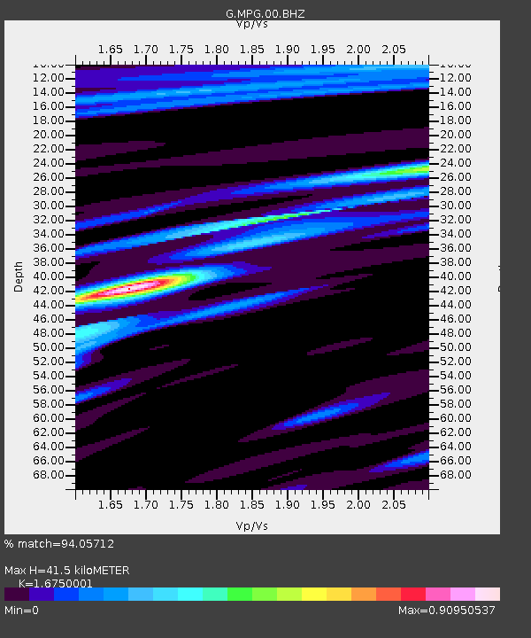
| Estimated Moho Depth: |
41.5 km |
| Estimated Crust Vp/Vs: |
1.68 |
| Assumed Crust Vp: |
6.472 km/s |
| Estimated Crust Vs: |
3.864 km/s |
| Estimated Crust Poisson's Ratio: |
0.22 |
|
| Radial Match: |
94.05712 % |
| Radial Bump: |
356 |
| Transverse Match: |
87.37779 % |
| Transverse Bump: |
400 |
| SOD ConfigId: |
2028011 |
| Insert Time: |
2017-04-17 17:41:58.304 +0000 |
| GWidth: |
2.5 |
| Max Bumps: |
400 |
| Tol: |
0.001 |
|
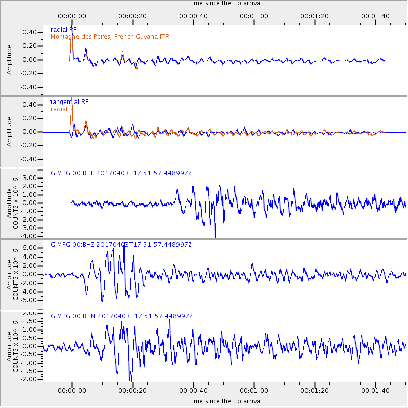
Signal To Noise
| Channel | StoN | STA | LTA |
| G:MPG:00:BHZ:20170403T17:51:57.448997Z | 4.344757 | 1.2865777E-6 | 2.961219E-7 |
| G:MPG:00:BHN:20170403T17:51:57.448997Z | 0.90190285 | 1.8567098E-7 | 2.0586583E-7 |
| G:MPG:00:BHE:20170403T17:51:57.448997Z | 3.233497 | 5.131921E-7 | 1.5871119E-7 |
| Arrivals |
| Ps | 4.5 SECOND |
| PpPs | 17 SECOND |
| PsPs/PpSs | 21 SECOND |


