You are here: Home > Network List > GT - Global Telemetered Seismograph Network (USAF/USGS) Stations List
> Station LPAZ La Paz , Bolivia > Earthquake Result Viewer
LPAZ La Paz , Bolivia - Earthquake Result Viewer
| Earthquake location: |
Botswana |
| Earthquake latitude/longitude: |
-22.7/25.1 |
| Earthquake time(UTC): |
2017/04/03 (093) 17:40:18 GMT |
| Earthquake Depth: |
29 km |
| Earthquake Magnitude: |
6.5 Mww |
| Earthquake Catalog/Contributor: |
NEIC PDE/us |
|
| Network: |
GT Global Telemetered Seismograph Network (USAF/USGS) |
| Station: |
LPAZ La Paz , Bolivia |
| Lat/Lon: |
16.17 S/68.08 W |
| Elevation: |
4817 m |
|
| Distance: |
86.8 deg |
| Az: |
253.928 deg |
| Baz: |
112.523 deg |
| Ray Param: |
0.043763645 |
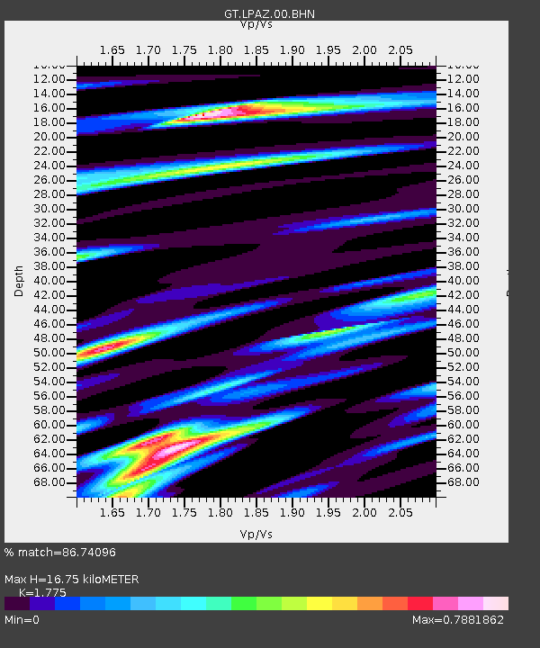
| Estimated Moho Depth: |
16.75 km |
| Estimated Crust Vp/Vs: |
1.77 |
| Assumed Crust Vp: |
6.454 km/s |
| Estimated Crust Vs: |
3.636 km/s |
| Estimated Crust Poisson's Ratio: |
0.27 |
|
| Radial Match: |
86.74096 % |
| Radial Bump: |
400 |
| Transverse Match: |
89.868355 % |
| Transverse Bump: |
400 |
| SOD ConfigId: |
2028011 |
| Insert Time: |
2017-04-17 17:42:26.178 +0000 |
| GWidth: |
2.5 |
| Max Bumps: |
400 |
| Tol: |
0.001 |
|
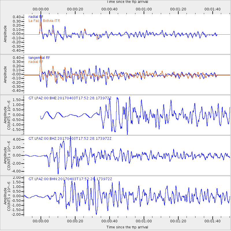
Signal To Noise
| Channel | StoN | STA | LTA |
| GT:LPAZ:00:BHZ:20170403T17:52:28.173972Z | 4.7783327 | 7.9367265E-7 | 1.6609823E-7 |
| GT:LPAZ:00:BHN:20170403T17:52:28.173972Z | 0.7110403 | 7.547816E-8 | 1.0615174E-7 |
| GT:LPAZ:00:BHE:20170403T17:52:28.173972Z | 1.5536518 | 2.8168566E-7 | 1.8130552E-7 |
| Arrivals |
| Ps | 2.1 SECOND |
| PpPs | 7.0 SECOND |
| PsPs/PpSs | 9.1 SECOND |


