You are here: Home > Network List > OH - Ohio Seismic Network Stations List
> Station KLOH Kiser Lake State Park Ohio > Earthquake Result Viewer
KLOH Kiser Lake State Park Ohio - Earthquake Result Viewer
| Earthquake location: |
Southeast Of Easter Island |
| Earthquake latitude/longitude: |
-41.2/-89.2 |
| Earthquake time(UTC): |
2019/12/18 (352) 04:44:14 GMT |
| Earthquake Depth: |
10 km |
| Earthquake Magnitude: |
5.5 Mww |
| Earthquake Catalog/Contributor: |
NEIC PDE/us |
|
| Network: |
OH Ohio Seismic Network |
| Station: |
KLOH Kiser Lake State Park Ohio |
| Lat/Lon: |
40.20 N/83.97 W |
| Elevation: |
350 m |
|
| Distance: |
81.1 deg |
| Az: |
4.08 deg |
| Baz: |
184.021 deg |
| Ray Param: |
0.047800355 |
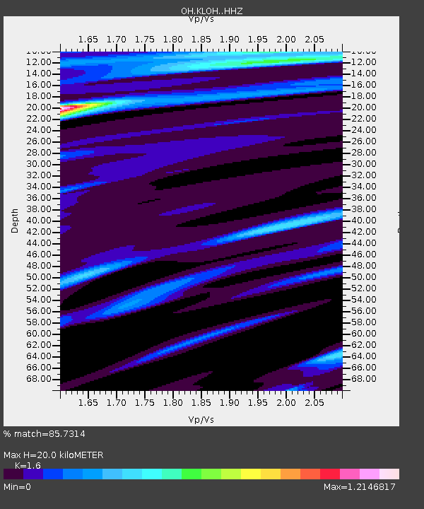
| Estimated Moho Depth: |
20.0 km |
| Estimated Crust Vp/Vs: |
1.60 |
| Assumed Crust Vp: |
6.498 km/s |
| Estimated Crust Vs: |
4.061 km/s |
| Estimated Crust Poisson's Ratio: |
0.18 |
|
| Radial Match: |
85.7314 % |
| Radial Bump: |
400 |
| Transverse Match: |
74.845 % |
| Transverse Bump: |
391 |
| SOD ConfigId: |
20358551 |
| Insert Time: |
2020-01-01 05:00:49.515 +0000 |
| GWidth: |
2.5 |
| Max Bumps: |
400 |
| Tol: |
0.001 |
|

Signal To Noise
| Channel | StoN | STA | LTA |
| OH:KLOH: :HHZ:20191218T04:55:58.499998Z | 1.7464396 | 1.4491623E-6 | 8.297809E-7 |
| OH:KLOH: :HHN:20191218T04:55:58.499998Z | 2.1049638 | 1.3893535E-6 | 6.600368E-7 |
| OH:KLOH: :HHE:20191218T04:55:58.499998Z | 0.89301723 | 6.753679E-7 | 7.5627645E-7 |
| Arrivals |
| Ps | 1.9 SECOND |
| PpPs | 7.8 SECOND |
| PsPs/PpSs | 9.7 SECOND |


