You are here: Home > Network List > CI - Caltech Regional Seismic Network Stations List
> Station SMM Simmler, CA, USA > Earthquake Result Viewer
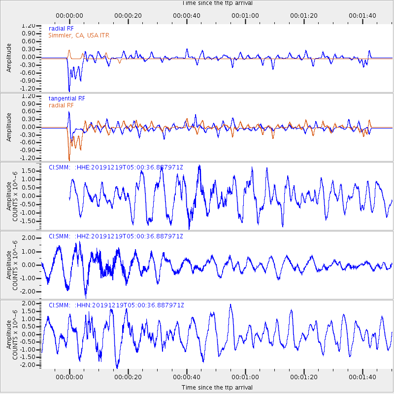
SMM Simmler, CA, USA - Earthquake Result Viewer
*The percent match for this event was below the threshold and hence no stack was calculated.
| Earthquake location: |
South Of Fiji Islands |
| Earthquake latitude/longitude: |
-26.3/178.4 |
| Earthquake time(UTC): |
2019/12/19 (353) 04:49:39 GMT |
| Earthquake Depth: |
624 km |
| Earthquake Magnitude: |
5.5 Mww |
| Earthquake Catalog/Contributor: |
NEIC PDE/us |
|
| Network: |
CI Caltech Regional Seismic Network |
| Station: |
SMM Simmler, CA, USA |
| Lat/Lon: |
35.31 N/120.00 W |
| Elevation: |
599 m |
|
| Distance: |
84.5 deg |
| Az: |
46.29 deg |
| Baz: |
232.514 deg |
| Ray Param: |
$rayparam |
*The percent match for this event was below the threshold and hence was not used in the summary stack. |
|
| Radial Match: |
76.418365 % |
| Radial Bump: |
400 |
| Transverse Match: |
60.265755 % |
| Transverse Bump: |
400 |
| SOD ConfigId: |
20358551 |
| Insert Time: |
2020-01-02 05:00:03.957 +0000 |
| GWidth: |
2.5 |
| Max Bumps: |
400 |
| Tol: |
0.001 |
|
Signal To Noise
| Channel | StoN | STA | LTA |
| CI:SMM: :HHZ:20191219T05:00:36.887971Z | 2.0707765 | 1.1088108E-6 | 5.3545654E-7 |
| CI:SMM: :HHN:20191219T05:00:36.887971Z | 1.1487668 | 8.5499215E-7 | 7.442695E-7 |
| CI:SMM: :HHE:20191219T05:00:36.887971Z | 1.7741469 | 1.0935476E-6 | 6.1637934E-7 |
| Arrivals |
| Ps | |
| PpPs | |
| PsPs/PpSs | |


