You are here: Home > Network List > IU - Global Seismograph Network (GSN - IRIS/USGS) Stations List
> Station PMG Port Moresby, New Guinea > Earthquake Result Viewer
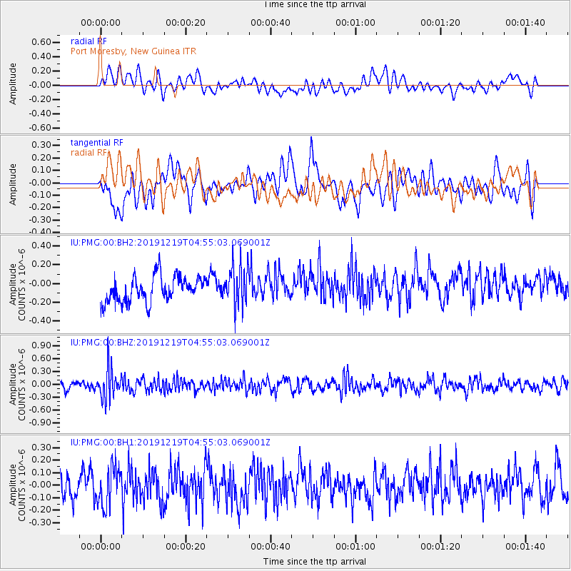
PMG Port Moresby, New Guinea - Earthquake Result Viewer
*The percent match for this event was below the threshold and hence no stack was calculated.
| Earthquake location: |
South Of Fiji Islands |
| Earthquake latitude/longitude: |
-26.3/178.4 |
| Earthquake time(UTC): |
2019/12/19 (353) 04:49:39 GMT |
| Earthquake Depth: |
624 km |
| Earthquake Magnitude: |
5.5 Mww |
| Earthquake Catalog/Contributor: |
NEIC PDE/us |
|
| Network: |
IU Global Seismograph Network (GSN - IRIS/USGS) |
| Station: |
PMG Port Moresby, New Guinea |
| Lat/Lon: |
9.40 S/147.16 E |
| Elevation: |
90 m |
|
| Distance: |
34.0 deg |
| Az: |
293.836 deg |
| Baz: |
123.673 deg |
| Ray Param: |
$rayparam |
*The percent match for this event was below the threshold and hence was not used in the summary stack. |
|
| Radial Match: |
42.37667 % |
| Radial Bump: |
400 |
| Transverse Match: |
52.06192 % |
| Transverse Bump: |
400 |
| SOD ConfigId: |
20358551 |
| Insert Time: |
2020-01-02 05:00:49.255 +0000 |
| GWidth: |
2.5 |
| Max Bumps: |
400 |
| Tol: |
0.001 |
|
Signal To Noise
| Channel | StoN | STA | LTA |
| IU:PMG:00:BHZ:20191219T04:55:03.069001Z | 3.980258 | 3.6441935E-7 | 9.155672E-8 |
| IU:PMG:00:BH1:20191219T04:55:03.069001Z | 1.767155 | 1.5409402E-7 | 8.719893E-8 |
| IU:PMG:00:BH2:20191219T04:55:03.069001Z | 1.6046516 | 2.1834943E-7 | 1.360728E-7 |
| Arrivals |
| Ps | |
| PpPs | |
| PsPs/PpSs | |


