You are here: Home > Network List > TA - USArray Transportable Network (new EarthScope stations) Stations List
> Station C16K Lisburne Hills, AK, USA > Earthquake Result Viewer
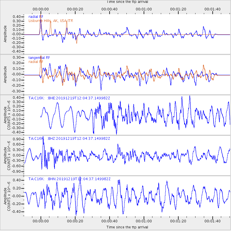
C16K Lisburne Hills, AK, USA - Earthquake Result Viewer
*The percent match for this event was below the threshold and hence no stack was calculated.
| Earthquake location: |
Mariana Islands |
| Earthquake latitude/longitude: |
18.6/145.6 |
| Earthquake time(UTC): |
2019/12/19 (353) 11:55:32 GMT |
| Earthquake Depth: |
187 km |
| Earthquake Magnitude: |
5.6 Mww |
| Earthquake Catalog/Contributor: |
NEIC PDE/us |
|
| Network: |
TA USArray Transportable Network (new EarthScope stations) |
| Station: |
C16K Lisburne Hills, AK, USA |
| Lat/Lon: |
68.27 N/165.34 W |
| Elevation: |
102 m |
|
| Distance: |
58.3 deg |
| Az: |
19.291 deg |
| Baz: |
237.33 deg |
| Ray Param: |
$rayparam |
*The percent match for this event was below the threshold and hence was not used in the summary stack. |
|
| Radial Match: |
52.03236 % |
| Radial Bump: |
400 |
| Transverse Match: |
71.07226 % |
| Transverse Bump: |
400 |
| SOD ConfigId: |
20358551 |
| Insert Time: |
2020-01-02 12:05:55.485 +0000 |
| GWidth: |
2.5 |
| Max Bumps: |
400 |
| Tol: |
0.001 |
|
Signal To Noise
| Channel | StoN | STA | LTA |
| TA:C16K: :BHZ:20191219T12:04:37.149982Z | 2.2934096 | 4.317388E-7 | 1.8825195E-7 |
| TA:C16K: :BHN:20191219T12:04:37.149982Z | 1.3964356 | 1.5214084E-7 | 1.08949415E-7 |
| TA:C16K: :BHE:20191219T12:04:37.149982Z | 1.0917177 | 1.7955205E-7 | 1.6446747E-7 |
| Arrivals |
| Ps | |
| PpPs | |
| PsPs/PpSs | |


