You are here: Home > Network List > TA - USArray Transportable Network (new EarthScope stations) Stations List
> Station D25K Kavik River, AK, USA > Earthquake Result Viewer
D25K Kavik River, AK, USA - Earthquake Result Viewer
*The percent match for this event was below the threshold and hence no stack was calculated.
| Earthquake location: |
Mariana Islands |
| Earthquake latitude/longitude: |
18.6/145.6 |
| Earthquake time(UTC): |
2019/12/19 (353) 11:55:32 GMT |
| Earthquake Depth: |
187 km |
| Earthquake Magnitude: |
5.6 Mww |
| Earthquake Catalog/Contributor: |
NEIC PDE/us |
|
| Network: |
TA USArray Transportable Network (new EarthScope stations) |
| Station: |
D25K Kavik River, AK, USA |
| Lat/Lon: |
69.32 N/146.38 W |
| Elevation: |
770 m |
|
| Distance: |
65.1 deg |
| Az: |
21.3 deg |
| Baz: |
255.976 deg |
| Ray Param: |
$rayparam |
*The percent match for this event was below the threshold and hence was not used in the summary stack. |
|
| Radial Match: |
70.778564 % |
| Radial Bump: |
400 |
| Transverse Match: |
71.769455 % |
| Transverse Bump: |
400 |
| SOD ConfigId: |
20358551 |
| Insert Time: |
2020-01-02 12:06:00.833 +0000 |
| GWidth: |
2.5 |
| Max Bumps: |
400 |
| Tol: |
0.001 |
|
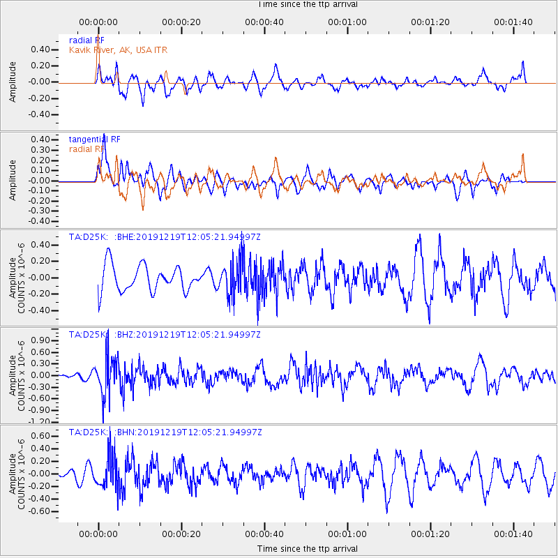
Signal To Noise
| Channel | StoN | STA | LTA |
| TA:D25K: :BHZ:20191219T12:05:21.94997Z | 5.091137 | 4.9069723E-7 | 9.6382635E-8 |
| TA:D25K: :BHN:20191219T12:05:21.94997Z | 3.2462986 | 2.6130363E-7 | 8.049279E-8 |
| TA:D25K: :BHE:20191219T12:05:21.94997Z | 1.2998923 | 2.0146715E-7 | 1.5498757E-7 |
| Arrivals |
| Ps | |
| PpPs | |
| PsPs/PpSs | |


