You are here: Home > Network List > TA - USArray Transportable Network (new EarthScope stations) Stations List
> Station E20K Nigu River, AK, USA > Earthquake Result Viewer
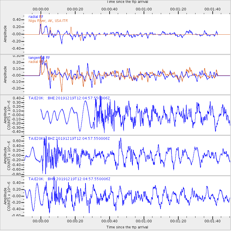
E20K Nigu River, AK, USA - Earthquake Result Viewer
*The percent match for this event was below the threshold and hence no stack was calculated.
| Earthquake location: |
Mariana Islands |
| Earthquake latitude/longitude: |
18.6/145.6 |
| Earthquake time(UTC): |
2019/12/19 (353) 11:55:32 GMT |
| Earthquake Depth: |
187 km |
| Earthquake Magnitude: |
5.6 Mww |
| Earthquake Catalog/Contributor: |
NEIC PDE/us |
|
| Network: |
TA USArray Transportable Network (new EarthScope stations) |
| Station: |
E20K Nigu River, AK, USA |
| Lat/Lon: |
68.26 N/156.19 W |
| Elevation: |
866 m |
|
| Distance: |
61.3 deg |
| Az: |
21.155 deg |
| Baz: |
246.767 deg |
| Ray Param: |
$rayparam |
*The percent match for this event was below the threshold and hence was not used in the summary stack. |
|
| Radial Match: |
56.453568 % |
| Radial Bump: |
400 |
| Transverse Match: |
45.04659 % |
| Transverse Bump: |
400 |
| SOD ConfigId: |
20358551 |
| Insert Time: |
2020-01-02 12:06:03.918 +0000 |
| GWidth: |
2.5 |
| Max Bumps: |
400 |
| Tol: |
0.001 |
|
Signal To Noise
| Channel | StoN | STA | LTA |
| TA:E20K: :BHZ:20191219T12:04:57.550006Z | 2.073995 | 3.88447E-7 | 1.8729409E-7 |
| TA:E20K: :BHN:20191219T12:04:57.550006Z | 1.8780644 | 2.0617023E-7 | 1.0977804E-7 |
| TA:E20K: :BHE:20191219T12:04:57.550006Z | 1.7308246 | 2.3156252E-7 | 1.3378741E-7 |
| Arrivals |
| Ps | |
| PpPs | |
| PsPs/PpSs | |


