You are here: Home > Network List > US - United States National Seismic Network Stations List
> Station NEW Newport, Washington, USA > Earthquake Result Viewer
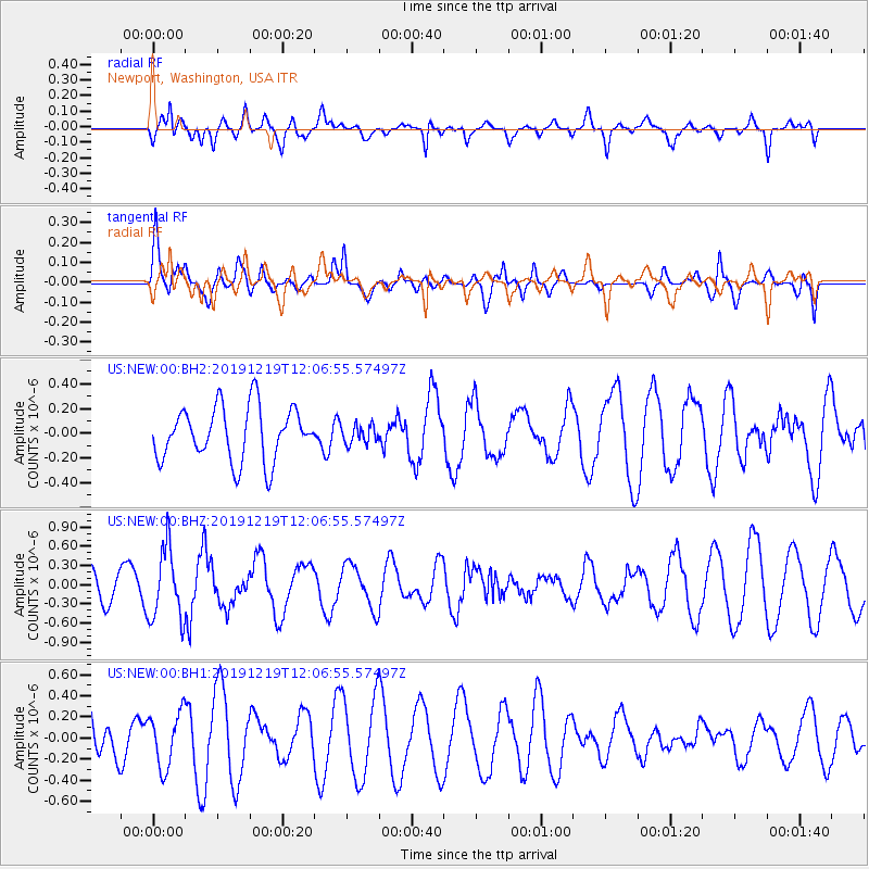
NEW Newport, Washington, USA - Earthquake Result Viewer
*The percent match for this event was below the threshold and hence no stack was calculated.
| Earthquake location: |
Mariana Islands |
| Earthquake latitude/longitude: |
18.6/145.6 |
| Earthquake time(UTC): |
2019/12/19 (353) 11:55:32 GMT |
| Earthquake Depth: |
187 km |
| Earthquake Magnitude: |
5.6 Mww |
| Earthquake Catalog/Contributor: |
NEIC PDE/us |
|
| Network: |
US United States National Seismic Network |
| Station: |
NEW Newport, Washington, USA |
| Lat/Lon: |
48.26 N/117.12 W |
| Elevation: |
760 m |
|
| Distance: |
81.1 deg |
| Az: |
42.14 deg |
| Baz: |
287.714 deg |
| Ray Param: |
$rayparam |
*The percent match for this event was below the threshold and hence was not used in the summary stack. |
|
| Radial Match: |
48.321884 % |
| Radial Bump: |
400 |
| Transverse Match: |
35.75551 % |
| Transverse Bump: |
400 |
| SOD ConfigId: |
20358551 |
| Insert Time: |
2020-01-02 12:06:55.335 +0000 |
| GWidth: |
2.5 |
| Max Bumps: |
400 |
| Tol: |
0.001 |
|
Signal To Noise
| Channel | StoN | STA | LTA |
| US:NEW:00:BHZ:20191219T12:06:55.57497Z | 2.536575 | 5.642122E-7 | 2.224307E-7 |
| US:NEW:00:BH1:20191219T12:06:55.57497Z | 1.1072377 | 2.586309E-7 | 2.335821E-7 |
| US:NEW:00:BH2:20191219T12:06:55.57497Z | 0.3400516 | 7.3125385E-8 | 2.1504202E-7 |
| Arrivals |
| Ps | |
| PpPs | |
| PsPs/PpSs | |


