You are here: Home > Network List > CI - Caltech Regional Seismic Network Stations List
> Station FUR Furnace Creek, CA, USA > Earthquake Result Viewer
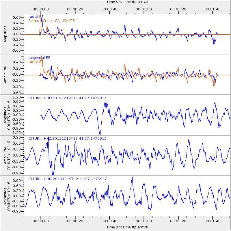
FUR Furnace Creek, CA, USA - Earthquake Result Viewer
*The percent match for this event was below the threshold and hence no stack was calculated.
| Earthquake location: |
Near Coast Of Guatemala |
| Earthquake latitude/longitude: |
13.7/-91.3 |
| Earthquake time(UTC): |
2019/12/19 (353) 12:35:32 GMT |
| Earthquake Depth: |
31 km |
| Earthquake Magnitude: |
5.9 Mww |
| Earthquake Catalog/Contributor: |
NEIC PDE/us |
|
| Network: |
CI Caltech Regional Seismic Network |
| Station: |
FUR Furnace Creek, CA, USA |
| Lat/Lon: |
36.47 N/116.86 W |
| Elevation: |
-37.0 m |
|
| Distance: |
32.2 deg |
| Az: |
319.297 deg |
| Baz: |
128.157 deg |
| Ray Param: |
$rayparam |
*The percent match for this event was below the threshold and hence was not used in the summary stack. |
|
| Radial Match: |
66.32581 % |
| Radial Bump: |
400 |
| Transverse Match: |
51.228687 % |
| Transverse Bump: |
340 |
| SOD ConfigId: |
20358551 |
| Insert Time: |
2020-01-02 12:44:55.434 +0000 |
| GWidth: |
2.5 |
| Max Bumps: |
400 |
| Tol: |
0.001 |
|
Signal To Noise
| Channel | StoN | STA | LTA |
| CI:FUR: :HHZ:20191219T12:41:27.147991Z | 1.976322 | 4.167726E-7 | 2.1088293E-7 |
| CI:FUR: :HHN:20191219T12:41:27.147991Z | 1.1494062 | 3.705048E-7 | 3.223445E-7 |
| CI:FUR: :HHE:20191219T12:41:27.147991Z | 2.9706204 | 6.0965897E-7 | 2.052295E-7 |
| Arrivals |
| Ps | |
| PpPs | |
| PsPs/PpSs | |


