You are here: Home > Network List > CN - Canadian National Seismograph Network Stations List
> Station INK INUVIK, NT > Earthquake Result Viewer
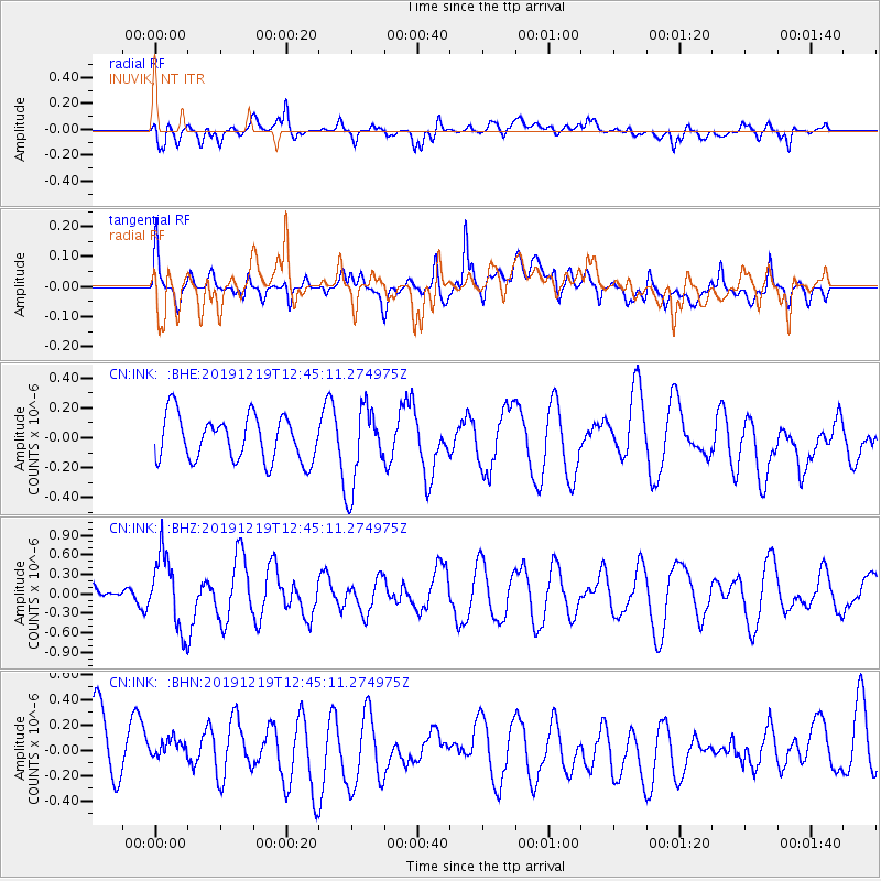
INK INUVIK, NT - Earthquake Result Viewer
*The percent match for this event was below the threshold and hence no stack was calculated.
| Earthquake location: |
Near Coast Of Guatemala |
| Earthquake latitude/longitude: |
13.7/-91.3 |
| Earthquake time(UTC): |
2019/12/19 (353) 12:35:32 GMT |
| Earthquake Depth: |
31 km |
| Earthquake Magnitude: |
5.9 Mww |
| Earthquake Catalog/Contributor: |
NEIC PDE/us |
|
| Network: |
CN Canadian National Seismograph Network |
| Station: |
INK INUVIK, NT |
| Lat/Lon: |
68.31 N/133.53 W |
| Elevation: |
44 m |
|
| Distance: |
60.9 deg |
| Az: |
343.393 deg |
| Baz: |
131.653 deg |
| Ray Param: |
$rayparam |
*The percent match for this event was below the threshold and hence was not used in the summary stack. |
|
| Radial Match: |
55.245613 % |
| Radial Bump: |
400 |
| Transverse Match: |
46.289024 % |
| Transverse Bump: |
400 |
| SOD ConfigId: |
20358551 |
| Insert Time: |
2020-01-02 12:45:25.697 +0000 |
| GWidth: |
2.5 |
| Max Bumps: |
400 |
| Tol: |
0.001 |
|
Signal To Noise
| Channel | StoN | STA | LTA |
| CN:INK: :BHZ:20191219T12:45:11.274975Z | 2.34936 | 5.6194193E-7 | 2.3918938E-7 |
| CN:INK: :BHN:20191219T12:45:11.274975Z | 0.524996 | 1.3491736E-7 | 2.5698742E-7 |
| CN:INK: :BHE:20191219T12:45:11.274975Z | 1.7936313 | 2.683735E-7 | 1.4962579E-7 |
| Arrivals |
| Ps | |
| PpPs | |
| PsPs/PpSs | |


