You are here: Home > Network List > TA - USArray Transportable Network (new EarthScope stations) Stations List
> Station E18K Tukpahlearik Creek, AK, USA > Earthquake Result Viewer
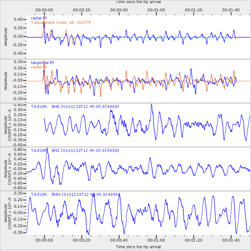
E18K Tukpahlearik Creek, AK, USA - Earthquake Result Viewer
*The percent match for this event was below the threshold and hence no stack was calculated.
| Earthquake location: |
Near Coast Of Guatemala |
| Earthquake latitude/longitude: |
13.7/-91.3 |
| Earthquake time(UTC): |
2019/12/19 (353) 12:35:32 GMT |
| Earthquake Depth: |
31 km |
| Earthquake Magnitude: |
5.9 Mww |
| Earthquake Catalog/Contributor: |
NEIC PDE/us |
|
| Network: |
TA USArray Transportable Network (new EarthScope stations) |
| Station: |
E18K Tukpahlearik Creek, AK, USA |
| Lat/Lon: |
67.42 N/160.60 W |
| Elevation: |
297 m |
|
| Distance: |
69.5 deg |
| Az: |
337.323 deg |
| Baz: |
103.976 deg |
| Ray Param: |
$rayparam |
*The percent match for this event was below the threshold and hence was not used in the summary stack. |
|
| Radial Match: |
64.70035 % |
| Radial Bump: |
400 |
| Transverse Match: |
66.4832 % |
| Transverse Bump: |
386 |
| SOD ConfigId: |
20358551 |
| Insert Time: |
2020-01-02 12:47:36.562 +0000 |
| GWidth: |
2.5 |
| Max Bumps: |
400 |
| Tol: |
0.001 |
|
Signal To Noise
| Channel | StoN | STA | LTA |
| TA:E18K: :BHZ:20191219T12:46:06.924999Z | 3.208869 | 4.6886387E-7 | 1.46115E-7 |
| TA:E18K: :BHN:20191219T12:46:06.924999Z | 0.61877626 | 8.41337E-8 | 1.359679E-7 |
| TA:E18K: :BHE:20191219T12:46:06.924999Z | 0.9456928 | 1.0884838E-7 | 1.1509909E-7 |
| Arrivals |
| Ps | |
| PpPs | |
| PsPs/PpSs | |


