You are here: Home > Network List > IU - Global Seismograph Network (GSN - IRIS/USGS) Stations List
> Station FURI Mt. Furi, Ethiopia > Earthquake Result Viewer
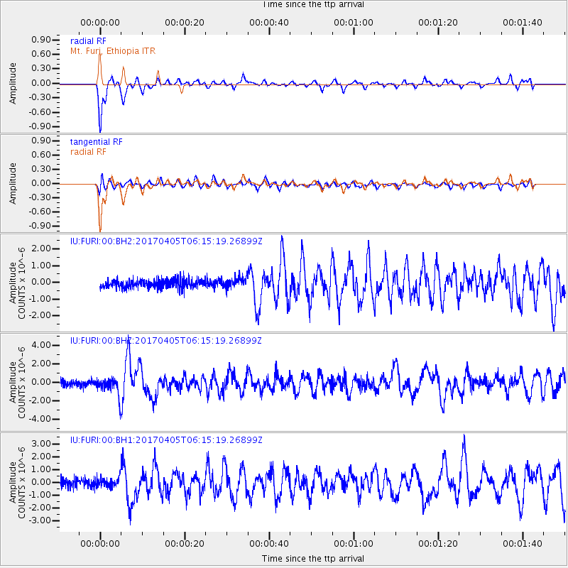
FURI Mt. Furi, Ethiopia - Earthquake Result Viewer
*The percent match for this event was below the threshold and hence no stack was calculated.
| Earthquake location: |
Northern And Central Iran |
| Earthquake latitude/longitude: |
35.8/60.4 |
| Earthquake time(UTC): |
2017/04/05 (095) 06:09:12 GMT |
| Earthquake Depth: |
13 km |
| Earthquake Magnitude: |
6.1 Mww |
| Earthquake Catalog/Contributor: |
NEIC PDE/us |
|
| Network: |
IU Global Seismograph Network (GSN - IRIS/USGS) |
| Station: |
FURI Mt. Furi, Ethiopia |
| Lat/Lon: |
8.90 N/38.68 E |
| Elevation: |
2570 m |
|
| Distance: |
33.3 deg |
| Az: |
221.804 deg |
| Baz: |
33.257 deg |
| Ray Param: |
$rayparam |
*The percent match for this event was below the threshold and hence was not used in the summary stack. |
|
| Radial Match: |
71.20082 % |
| Radial Bump: |
400 |
| Transverse Match: |
53.53823 % |
| Transverse Bump: |
400 |
| SOD ConfigId: |
2028011 |
| Insert Time: |
2017-04-19 06:11:14.469 +0000 |
| GWidth: |
2.5 |
| Max Bumps: |
400 |
| Tol: |
0.001 |
|
Signal To Noise
| Channel | StoN | STA | LTA |
| IU:FURI:00:BHZ:20170405T06:15:19.26899Z | 2.6046 | 1.0698352E-6 | 4.1074838E-7 |
| IU:FURI:00:BH1:20170405T06:15:19.26899Z | 1.233531 | 4.0637127E-7 | 3.2943743E-7 |
| IU:FURI:00:BH2:20170405T06:15:19.26899Z | 1.2253785 | 3.1409633E-7 | 2.5632596E-7 |
| Arrivals |
| Ps | |
| PpPs | |
| PsPs/PpSs | |


