You are here: Home > Network List > KO - Kandilli Observatory Digital Broadband Seismic Network Stations List
> Station MDUB Mudurnu-Bolu-Turkey > Earthquake Result Viewer
MDUB Mudurnu-Bolu-Turkey - Earthquake Result Viewer
| Earthquake location: |
Hindu Kush Region, Afghanistan |
| Earthquake latitude/longitude: |
36.5/70.4 |
| Earthquake time(UTC): |
2019/12/20 (354) 11:39:52 GMT |
| Earthquake Depth: |
210 km |
| Earthquake Magnitude: |
6.1 Mww |
| Earthquake Catalog/Contributor: |
NEIC PDE/us |
|
| Network: |
KO Kandilli Observatory Digital Broadband Seismic Network |
| Station: |
MDUB Mudurnu-Bolu-Turkey |
| Lat/Lon: |
40.47 N/31.20 E |
| Elevation: |
1109 m |
|
| Distance: |
30.8 deg |
| Az: |
289.461 deg |
| Baz: |
84.521 deg |
| Ray Param: |
0.07871384 |
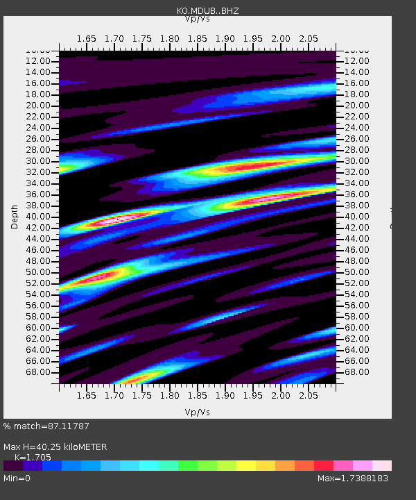
| Estimated Moho Depth: |
40.25 km |
| Estimated Crust Vp/Vs: |
1.71 |
| Assumed Crust Vp: |
6.287 km/s |
| Estimated Crust Vs: |
3.688 km/s |
| Estimated Crust Poisson's Ratio: |
0.24 |
|
| Radial Match: |
87.11787 % |
| Radial Bump: |
400 |
| Transverse Match: |
87.21506 % |
| Transverse Bump: |
400 |
| SOD ConfigId: |
20358551 |
| Insert Time: |
2020-01-03 11:56:52.978 +0000 |
| GWidth: |
2.5 |
| Max Bumps: |
400 |
| Tol: |
0.001 |
|

Signal To Noise
| Channel | StoN | STA | LTA |
| KO:MDUB: :BHZ:20191220T11:45:18.400015Z | 14.4386215 | 4.2232E-6 | 2.924933E-7 |
| KO:MDUB: :BHN:20191220T11:45:18.400015Z | 1.118054 | 5.6886194E-9 | 5.0879647E-9 |
| KO:MDUB: :BHE:20191220T11:45:18.400015Z | 5.728758 | 2.3317605E-6 | 4.0702724E-7 |
| Arrivals |
| Ps | 4.9 SECOND |
| PpPs | 16 SECOND |
| PsPs/PpSs | 21 SECOND |


