You are here: Home > Network List > TA - USArray Transportable Network (new EarthScope stations) Stations List
> Station B18K Kokolik River, AK, USA > Earthquake Result Viewer
B18K Kokolik River, AK, USA - Earthquake Result Viewer
| Earthquake location: |
Hindu Kush Region, Afghanistan |
| Earthquake latitude/longitude: |
36.5/70.4 |
| Earthquake time(UTC): |
2019/12/20 (354) 11:39:52 GMT |
| Earthquake Depth: |
210 km |
| Earthquake Magnitude: |
6.1 Mww |
| Earthquake Catalog/Contributor: |
NEIC PDE/us |
|
| Network: |
TA USArray Transportable Network (new EarthScope stations) |
| Station: |
B18K Kokolik River, AK, USA |
| Lat/Lon: |
69.36 N/161.80 W |
| Elevation: |
222 m |
|
| Distance: |
67.7 deg |
| Az: |
17.632 deg |
| Baz: |
316.514 deg |
| Ray Param: |
0.056176484 |
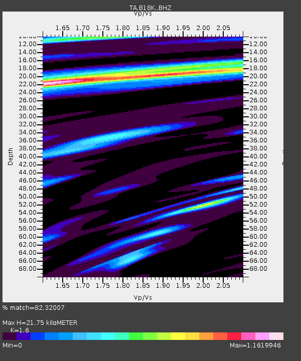
| Estimated Moho Depth: |
21.75 km |
| Estimated Crust Vp/Vs: |
1.60 |
| Assumed Crust Vp: |
5.906 km/s |
| Estimated Crust Vs: |
3.692 km/s |
| Estimated Crust Poisson's Ratio: |
0.18 |
|
| Radial Match: |
82.32007 % |
| Radial Bump: |
400 |
| Transverse Match: |
73.94337 % |
| Transverse Bump: |
400 |
| SOD ConfigId: |
20358551 |
| Insert Time: |
2020-01-03 11:58:09.722 +0000 |
| GWidth: |
2.5 |
| Max Bumps: |
400 |
| Tol: |
0.001 |
|
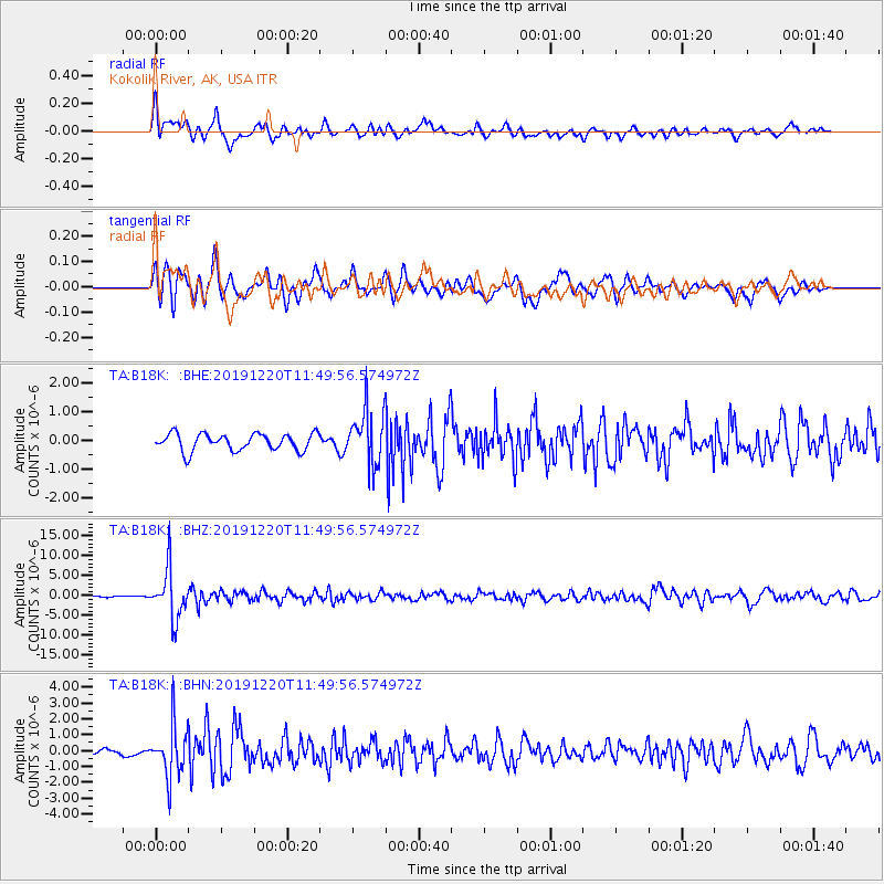
Signal To Noise
| Channel | StoN | STA | LTA |
| TA:B18K: :BHZ:20191220T11:49:56.574972Z | 20.841856 | 6.2730687E-6 | 3.009842E-7 |
| TA:B18K: :BHN:20191220T11:49:56.574972Z | 7.1547604 | 1.595554E-6 | 2.2300593E-7 |
| TA:B18K: :BHE:20191220T11:49:56.574972Z | 3.185673 | 9.4971864E-7 | 2.9812182E-7 |
| Arrivals |
| Ps | 2.3 SECOND |
| PpPs | 9.2 SECOND |
| PsPs/PpSs | 12 SECOND |


