You are here: Home > Network List > TA - USArray Transportable Network (new EarthScope stations) Stations List
> Station C19K Lookout Ridge, AK, USA > Earthquake Result Viewer
C19K Lookout Ridge, AK, USA - Earthquake Result Viewer
| Earthquake location: |
Hindu Kush Region, Afghanistan |
| Earthquake latitude/longitude: |
36.5/70.4 |
| Earthquake time(UTC): |
2019/12/20 (354) 11:39:52 GMT |
| Earthquake Depth: |
210 km |
| Earthquake Magnitude: |
6.1 Mww |
| Earthquake Catalog/Contributor: |
NEIC PDE/us |
|
| Network: |
TA USArray Transportable Network (new EarthScope stations) |
| Station: |
C19K Lookout Ridge, AK, USA |
| Lat/Lon: |
69.10 N/159.59 W |
| Elevation: |
745 m |
|
| Distance: |
68.4 deg |
| Az: |
17.195 deg |
| Baz: |
318.419 deg |
| Ray Param: |
0.055706788 |
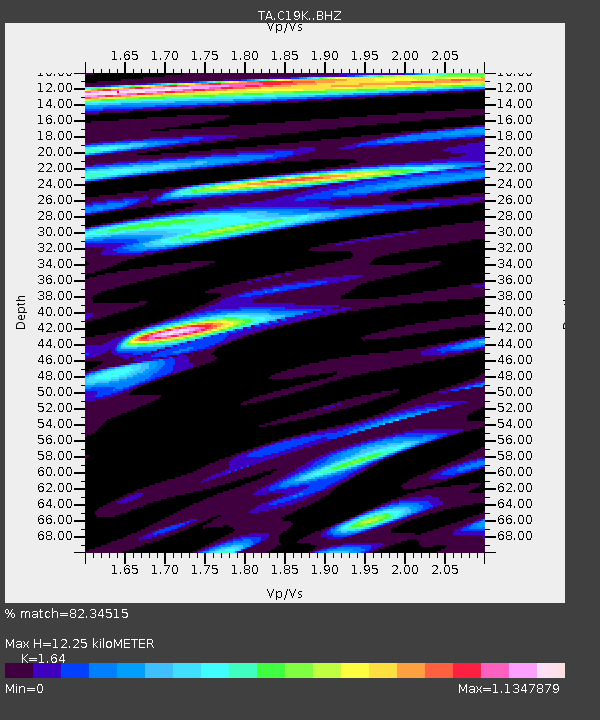
| Estimated Moho Depth: |
12.25 km |
| Estimated Crust Vp/Vs: |
1.64 |
| Assumed Crust Vp: |
6.221 km/s |
| Estimated Crust Vs: |
3.793 km/s |
| Estimated Crust Poisson's Ratio: |
0.20 |
|
| Radial Match: |
82.34515 % |
| Radial Bump: |
400 |
| Transverse Match: |
74.74562 % |
| Transverse Bump: |
400 |
| SOD ConfigId: |
20358551 |
| Insert Time: |
2020-01-03 11:58:14.487 +0000 |
| GWidth: |
2.5 |
| Max Bumps: |
400 |
| Tol: |
0.001 |
|

Signal To Noise
| Channel | StoN | STA | LTA |
| TA:C19K: :BHZ:20191220T11:50:01.074972Z | 27.327044 | 5.4807524E-6 | 2.0056149E-7 |
| TA:C19K: :BHN:20191220T11:50:01.074972Z | 10.960904 | 1.355515E-6 | 1.2366817E-7 |
| TA:C19K: :BHE:20191220T11:50:01.074972Z | 6.2276773 | 9.3695013E-7 | 1.5044937E-7 |
| Arrivals |
| Ps | 1.3 SECOND |
| PpPs | 5.0 SECOND |
| PsPs/PpSs | 6.3 SECOND |


