You are here: Home > Network List > TA - USArray Transportable Network (new EarthScope stations) Stations List
> Station C24K Franklin Bluffs, AK, USA > Earthquake Result Viewer
C24K Franklin Bluffs, AK, USA - Earthquake Result Viewer
| Earthquake location: |
Hindu Kush Region, Afghanistan |
| Earthquake latitude/longitude: |
36.5/70.4 |
| Earthquake time(UTC): |
2019/12/20 (354) 11:39:52 GMT |
| Earthquake Depth: |
210 km |
| Earthquake Magnitude: |
6.1 Mww |
| Earthquake Catalog/Contributor: |
NEIC PDE/us |
|
| Network: |
TA USArray Transportable Network (new EarthScope stations) |
| Station: |
C24K Franklin Bluffs, AK, USA |
| Lat/Lon: |
69.72 N/148.70 W |
| Elevation: |
115 m |
|
| Distance: |
70.3 deg |
| Az: |
13.522 deg |
| Baz: |
327.309 deg |
| Ray Param: |
0.054508314 |
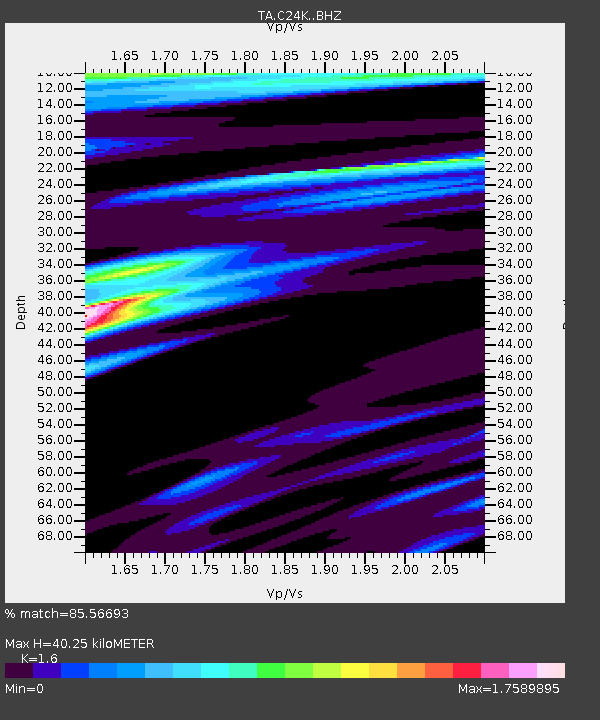
| Estimated Moho Depth: |
40.25 km |
| Estimated Crust Vp/Vs: |
1.60 |
| Assumed Crust Vp: |
6.316 km/s |
| Estimated Crust Vs: |
3.948 km/s |
| Estimated Crust Poisson's Ratio: |
0.18 |
|
| Radial Match: |
85.56693 % |
| Radial Bump: |
383 |
| Transverse Match: |
54.34748 % |
| Transverse Bump: |
400 |
| SOD ConfigId: |
20358551 |
| Insert Time: |
2020-01-03 11:58:16.430 +0000 |
| GWidth: |
2.5 |
| Max Bumps: |
400 |
| Tol: |
0.001 |
|

Signal To Noise
| Channel | StoN | STA | LTA |
| TA:C24K: :BHZ:20191220T11:50:12.250021Z | 19.094542 | 6.4084866E-6 | 3.3561878E-7 |
| TA:C24K: :BHN:20191220T11:50:12.250021Z | 3.1214385 | 1.6261564E-6 | 5.209638E-7 |
| TA:C24K: :BHE:20191220T11:50:12.250021Z | 2.1075904 | 1.0450508E-6 | 4.95851E-7 |
| Arrivals |
| Ps | 4.0 SECOND |
| PpPs | 16 SECOND |
| PsPs/PpSs | 20 SECOND |


