You are here: Home > Network List > TA - USArray Transportable Network (new EarthScope stations) Stations List
> Station E19K Redstone River, AK, USA > Earthquake Result Viewer
E19K Redstone River, AK, USA - Earthquake Result Viewer
| Earthquake location: |
Hindu Kush Region, Afghanistan |
| Earthquake latitude/longitude: |
36.5/70.4 |
| Earthquake time(UTC): |
2019/12/20 (354) 11:39:52 GMT |
| Earthquake Depth: |
210 km |
| Earthquake Magnitude: |
6.1 Mww |
| Earthquake Catalog/Contributor: |
NEIC PDE/us |
|
| Network: |
TA USArray Transportable Network (new EarthScope stations) |
| Station: |
E19K Redstone River, AK, USA |
| Lat/Lon: |
67.46 N/157.23 W |
| Elevation: |
441 m |
|
| Distance: |
70.3 deg |
| Az: |
17.628 deg |
| Baz: |
320.759 deg |
| Ray Param: |
0.05450993 |
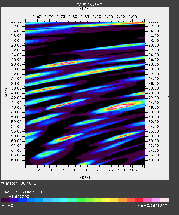
| Estimated Moho Depth: |
45.5 km |
| Estimated Crust Vp/Vs: |
1.99 |
| Assumed Crust Vp: |
6.577 km/s |
| Estimated Crust Vs: |
3.301 km/s |
| Estimated Crust Poisson's Ratio: |
0.33 |
|
| Radial Match: |
88.4876 % |
| Radial Bump: |
400 |
| Transverse Match: |
74.92883 % |
| Transverse Bump: |
400 |
| SOD ConfigId: |
20358551 |
| Insert Time: |
2020-01-03 11:58:24.701 +0000 |
| GWidth: |
2.5 |
| Max Bumps: |
400 |
| Tol: |
0.001 |
|

Signal To Noise
| Channel | StoN | STA | LTA |
| TA:E19K: :BHZ:20191220T11:50:12.250021Z | 27.393955 | 3.622261E-6 | 1.3222848E-7 |
| TA:E19K: :BHN:20191220T11:50:12.250021Z | 10.873564 | 1.4721361E-6 | 1.3538671E-7 |
| TA:E19K: :BHE:20191220T11:50:12.250021Z | 13.044924 | 1.1417694E-6 | 8.7525954E-8 |
| Arrivals |
| Ps | 7.1 SECOND |
| PpPs | 20 SECOND |
| PsPs/PpSs | 27 SECOND |


