You are here: Home > Network List > TA - USArray Transportable Network (new EarthScope stations) Stations List
> Station G31M Satah River, YT, CAN > Earthquake Result Viewer
G31M Satah River, YT, CAN - Earthquake Result Viewer
| Earthquake location: |
Hindu Kush Region, Afghanistan |
| Earthquake latitude/longitude: |
36.5/70.4 |
| Earthquake time(UTC): |
2019/12/20 (354) 11:39:52 GMT |
| Earthquake Depth: |
210 km |
| Earthquake Magnitude: |
6.1 Mww |
| Earthquake Catalog/Contributor: |
NEIC PDE/us |
|
| Network: |
TA USArray Transportable Network (new EarthScope stations) |
| Station: |
G31M Satah River, YT, CAN |
| Lat/Lon: |
66.92 N/134.27 W |
| Elevation: |
61 m |
|
| Distance: |
75.1 deg |
| Az: |
9.815 deg |
| Baz: |
339.617 deg |
| Ray Param: |
0.051303357 |
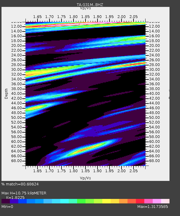
| Estimated Moho Depth: |
10.75 km |
| Estimated Crust Vp/Vs: |
1.82 |
| Assumed Crust Vp: |
6.171 km/s |
| Estimated Crust Vs: |
3.386 km/s |
| Estimated Crust Poisson's Ratio: |
0.28 |
|
| Radial Match: |
80.68624 % |
| Radial Bump: |
400 |
| Transverse Match: |
63.02627 % |
| Transverse Bump: |
400 |
| SOD ConfigId: |
20358551 |
| Insert Time: |
2020-01-03 11:58:45.280 +0000 |
| GWidth: |
2.5 |
| Max Bumps: |
400 |
| Tol: |
0.001 |
|

Signal To Noise
| Channel | StoN | STA | LTA |
| TA:G31M: :BHZ:20191220T11:50:40.925009Z | 15.126095 | 5.476295E-6 | 3.6204287E-7 |
| TA:G31M: :BHN:20191220T11:50:40.925009Z | 4.637572 | 1.5017143E-6 | 3.238148E-7 |
| TA:G31M: :BHE:20191220T11:50:40.925009Z | 2.1671355 | 8.2749807E-7 | 3.8183958E-7 |
| Arrivals |
| Ps | 1.5 SECOND |
| PpPs | 4.8 SECOND |
| PsPs/PpSs | 6.3 SECOND |


