You are here: Home > Network List > US - United States National Seismic Network Stations List
> Station DGMT Dagmar, Montana, USA > Earthquake Result Viewer
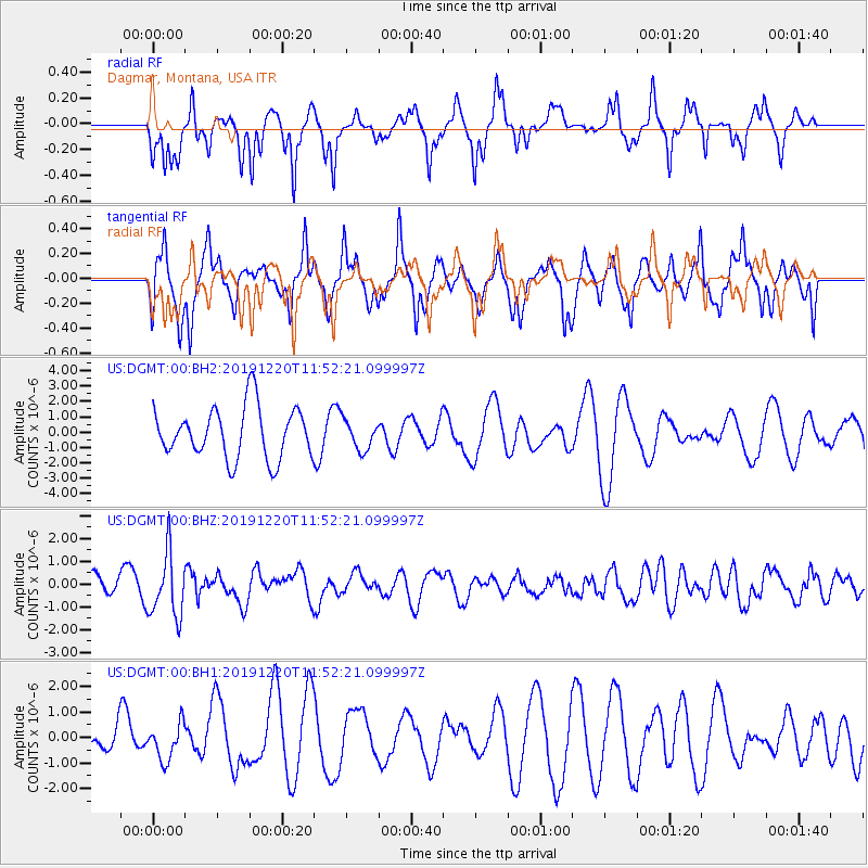
DGMT Dagmar, Montana, USA - Earthquake Result Viewer
*The percent match for this event was below the threshold and hence no stack was calculated.
| Earthquake location: |
Hindu Kush Region, Afghanistan |
| Earthquake latitude/longitude: |
36.5/70.4 |
| Earthquake time(UTC): |
2019/12/20 (354) 11:39:52 GMT |
| Earthquake Depth: |
210 km |
| Earthquake Magnitude: |
6.1 Mww |
| Earthquake Catalog/Contributor: |
NEIC PDE/us |
|
| Network: |
US United States National Seismic Network |
| Station: |
DGMT Dagmar, Montana, USA |
| Lat/Lon: |
48.47 N/104.20 W |
| Elevation: |
0.0 m |
|
| Distance: |
95.2 deg |
| Az: |
356.416 deg |
| Baz: |
4.339 deg |
| Ray Param: |
$rayparam |
*The percent match for this event was below the threshold and hence was not used in the summary stack. |
|
| Radial Match: |
59.747704 % |
| Radial Bump: |
325 |
| Transverse Match: |
47.15157 % |
| Transverse Bump: |
315 |
| SOD ConfigId: |
20358551 |
| Insert Time: |
2020-01-03 11:59:40.029 +0000 |
| GWidth: |
2.5 |
| Max Bumps: |
400 |
| Tol: |
0.001 |
|
Signal To Noise
| Channel | StoN | STA | LTA |
| US:DGMT:00:BHZ:20191220T11:52:21.099997Z | 3.1876066 | 1.4038391E-6 | 4.404054E-7 |
| US:DGMT:00:BH1:20191220T11:52:21.099997Z | 0.75474083 | 7.1764094E-7 | 9.5084425E-7 |
| US:DGMT:00:BH2:20191220T11:52:21.099997Z | 0.5768796 | 9.589511E-7 | 1.6623071E-6 |
| Arrivals |
| Ps | |
| PpPs | |
| PsPs/PpSs | |


