You are here: Home > Network List > CI - Caltech Regional Seismic Network Stations List
> Station MPM Manuel Prospect Mine, California, USA > Earthquake Result Viewer
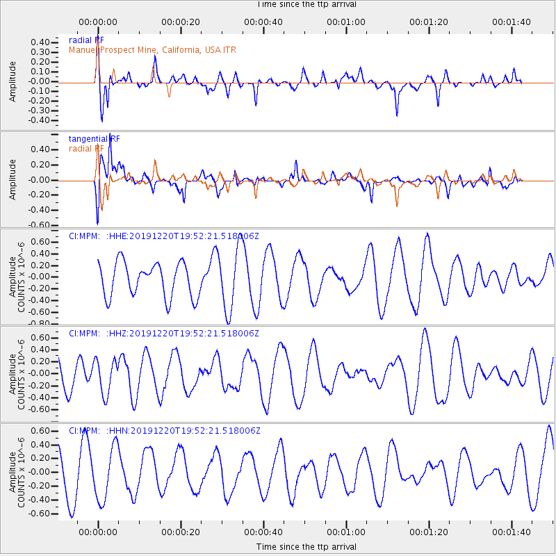
MPM Manuel Prospect Mine, California, USA - Earthquake Result Viewer
*The percent match for this event was below the threshold and hence no stack was calculated.
| Earthquake location: |
Southeast Of Honshu, Japan |
| Earthquake latitude/longitude: |
32.9/142.8 |
| Earthquake time(UTC): |
2019/12/20 (354) 19:40:52 GMT |
| Earthquake Depth: |
10 km |
| Earthquake Magnitude: |
5.3 Mww |
| Earthquake Catalog/Contributor: |
NEIC PDE/us |
|
| Network: |
CI Caltech Regional Seismic Network |
| Station: |
MPM Manuel Prospect Mine, California, USA |
| Lat/Lon: |
36.06 N/117.49 W |
| Elevation: |
185 m |
|
| Distance: |
78.4 deg |
| Az: |
54.615 deg |
| Baz: |
302.135 deg |
| Ray Param: |
$rayparam |
*The percent match for this event was below the threshold and hence was not used in the summary stack. |
|
| Radial Match: |
54.70529 % |
| Radial Bump: |
400 |
| Transverse Match: |
52.57831 % |
| Transverse Bump: |
400 |
| SOD ConfigId: |
20358551 |
| Insert Time: |
2020-01-03 19:47:46.025 +0000 |
| GWidth: |
2.5 |
| Max Bumps: |
400 |
| Tol: |
0.001 |
|
Signal To Noise
| Channel | StoN | STA | LTA |
| CI:MPM: :HHZ:20191220T19:52:21.518006Z | 1.3615246 | 2.8679727E-7 | 2.1064423E-7 |
| CI:MPM: :HHN:20191220T19:52:21.518006Z | 1.3632715 | 3.9016405E-7 | 2.861969E-7 |
| CI:MPM: :HHE:20191220T19:52:21.518006Z | 1.8797034 | 5.4404427E-7 | 2.8943094E-7 |
| Arrivals |
| Ps | |
| PpPs | |
| PsPs/PpSs | |


