You are here: Home > Network List > TA - USArray Transportable Network (new EarthScope stations) Stations List
> Station M31M Drury Creek, Yukon, CA > Earthquake Result Viewer
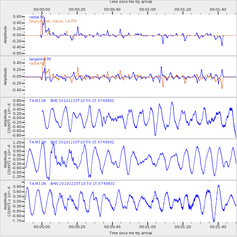
M31M Drury Creek, Yukon, CA - Earthquake Result Viewer
*The percent match for this event was below the threshold and hence no stack was calculated.
| Earthquake location: |
Southeast Of Honshu, Japan |
| Earthquake latitude/longitude: |
32.9/142.8 |
| Earthquake time(UTC): |
2019/12/20 (354) 19:40:52 GMT |
| Earthquake Depth: |
10 km |
| Earthquake Magnitude: |
5.3 Mww |
| Earthquake Catalog/Contributor: |
NEIC PDE/us |
|
| Network: |
TA USArray Transportable Network (new EarthScope stations) |
| Station: |
M31M Drury Creek, Yukon, CA |
| Lat/Lon: |
62.20 N/134.39 W |
| Elevation: |
639 m |
|
| Distance: |
58.2 deg |
| Az: |
33.162 deg |
| Baz: |
280.88 deg |
| Ray Param: |
$rayparam |
*The percent match for this event was below the threshold and hence was not used in the summary stack. |
|
| Radial Match: |
62.069458 % |
| Radial Bump: |
400 |
| Transverse Match: |
62.410694 % |
| Transverse Bump: |
400 |
| SOD ConfigId: |
20358551 |
| Insert Time: |
2020-01-03 19:52:47.532 +0000 |
| GWidth: |
2.5 |
| Max Bumps: |
400 |
| Tol: |
0.001 |
|
Signal To Noise
| Channel | StoN | STA | LTA |
| TA:M31M: :BHZ:20191220T19:50:15.674989Z | 1.9130683 | 9.837925E-7 | 5.142485E-7 |
| TA:M31M: :BHN:20191220T19:50:15.674989Z | 1.0477812 | 4.910913E-7 | 4.686964E-7 |
| TA:M31M: :BHE:20191220T19:50:15.674989Z | 0.9540553 | 2.9318514E-7 | 3.0730413E-7 |
| Arrivals |
| Ps | |
| PpPs | |
| PsPs/PpSs | |


